
Spenden
Rüste dich für dein nächstes Abenteuer:
Als Amazon-Partner verdient diese Seite an qualifizierten Käufen, ohne dass Ihnen zusätzliche Kosten entstehen.
Topografische Karte Brooklyn
Klicken Sie auf die Karte, um die Höhe anzuzeigen.
Spenden
Rüste dich für dein nächstes Abenteuer:
Als Amazon-Partner verdient diese Seite an qualifizierten Käufen, ohne dass Ihnen zusätzliche Kosten entstehen.
Über diese Karte
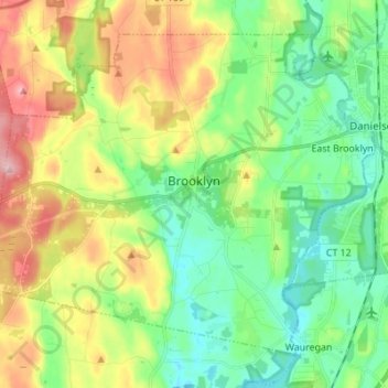
Name: Topografische Karte Brooklyn, Höhe, Relief.
Durchschnittliche Höhe: 102 m
Minimale Höhe: 36 m
Maximale Höhe: 222 m
Spenden
Rüste dich für dein nächstes Abenteuer:
Als Amazon-Partner verdient diese Seite an qualifizierten Käufen, ohne dass Ihnen zusätzliche Kosten entstehen.
Andere topografische Karten
Klicken Sie auf eine Karte, um ihre Topografie, ihre Höhe und ihr Relief anzuzeigen.
Killingly Center
United States > Connecticut > Northeastern Connecticut Planning Region > Killingly > Dayville
Durchschnittliche Höhe: 109 m
Central Village
United States > Connecticut > Northeastern Connecticut Planning Region > Plainfield
Durchschnittliche Höhe: 69 m
Elmville
United States > Connecticut > Northeastern Connecticut Planning Region > Killingly
Durchschnittliche Höhe: 106 m