
Spenden
Rüste dich für dein nächstes Abenteuer:
Als Amazon-Partner verdient diese Seite an qualifizierten Käufen, ohne dass Ihnen zusätzliche Kosten entstehen.
Topografische Karte Ellington
Klicken Sie auf die Karte, um die Höhe anzuzeigen.
Spenden
Rüste dich für dein nächstes Abenteuer:
Als Amazon-Partner verdient diese Seite an qualifizierten Käufen, ohne dass Ihnen zusätzliche Kosten entstehen.
Über diese Karte
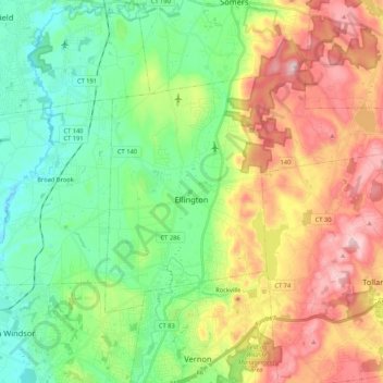
Name: Topografische Karte Ellington, Höhe, Relief.
Durchschnittliche Höhe: 124 m
Minimale Höhe: 7 m
Maximale Höhe: 315 m
Spenden
Rüste dich für dein nächstes Abenteuer:
Als Amazon-Partner verdient diese Seite an qualifizierten Käufen, ohne dass Ihnen zusätzliche Kosten entstehen.
Andere topografische Karten
Klicken Sie auf eine Karte, um ihre Topografie, ihre Höhe und ihr Relief anzuzeigen.
West Suffield
United States > Connecticut > Capitol Planning Region > Suffield
Durchschnittliche Höhe: 59 m
Plantsville
United States > Connecticut > Capitol Planning Region > Southington
Durchschnittliche Höhe: 57 m
Four Corners
United States > Connecticut > Capitol Planning Region > Terramuggus
Durchschnittliche Höhe: 143 m
Willington Hill
United States > Connecticut > Capitol Planning Region > Willington
Durchschnittliche Höhe: 197 m
Spenden
Rüste dich für dein nächstes Abenteuer:
Als Amazon-Partner verdient diese Seite an qualifizierten Käufen, ohne dass Ihnen zusätzliche Kosten entstehen.
Vernon Center
United States > Connecticut > Capitol Planning Region > Vernon
Durchschnittliche Höhe: 106 m
Parkville
United States > Connecticut > Capitol Planning Region > Hartford
Durchschnittliche Höhe: 23 m
Griswoldville
United States > Connecticut > Capitol Planning Region > Wethersfield
Durchschnittliche Höhe: 34 m
Clay Arsenal
United States > Connecticut > Capitol Planning Region > Hartford
Durchschnittliche Höhe: 18 m
Spenden
Rüste dich für dein nächstes Abenteuer:
Als Amazon-Partner verdient diese Seite an qualifizierten Käufen, ohne dass Ihnen zusätzliche Kosten entstehen.
North End
United States > Connecticut > Capitol Planning Region > Southington
Durchschnittliche Höhe: 68 m
Chaffeeville
United States > Connecticut > Capitol Planning Region > Mansfield
Durchschnittliche Höhe: 133 m
West District
United States > Connecticut > Capitol Planning Region > Farmington
Durchschnittliche Höhe: 92 m
Talcott Mountain
United States > Connecticut > Capitol Planning Region > Bloomfield
Durchschnittliche Höhe: 152 m
Spenden
Rüste dich für dein nächstes Abenteuer:
Als Amazon-Partner verdient diese Seite an qualifizierten Käufen, ohne dass Ihnen zusätzliche Kosten entstehen.
South Wethersfield
United States > Connecticut > Capitol Planning Region > Wethersfield > Griswoldville
Durchschnittliche Höhe: 22 m
East Berlin
United States > Connecticut > Capitol Planning Region > Berlin
Durchschnittliche Höhe: 30 m
Buckingham
United States > Connecticut > Capitol Planning Region > Glastonbury
Durchschnittliche Höhe: 131 m
North Coventry
United States > Connecticut > Capitol Planning Region > Coventry
Durchschnittliche Höhe: 195 m
Spenden
Rüste dich für dein nächstes Abenteuer:
Als Amazon-Partner verdient diese Seite an qualifizierten Käufen, ohne dass Ihnen zusätzliche Kosten entstehen.
Bishop's Corner
United States > Connecticut > Capitol Planning Region > West Hartford
Durchschnittliche Höhe: 47 m
Talcott Mountain
United States > Connecticut > Capitol Planning Region > Bloomfield
Durchschnittliche Höhe: 152 m
Johnson Hill
United States > Connecticut > Capitol Planning Region > West Hartford
Durchschnittliche Höhe: 34 m
Spenden
Rüste dich für dein nächstes Abenteuer:
Als Amazon-Partner verdient diese Seite an qualifizierten Käufen, ohne dass Ihnen zusätzliche Kosten entstehen.
Poquonock
United States > Connecticut > Capitol Planning Region > Windsor
Durchschnittliche Höhe: 36 m
Avon Park North
United States > Connecticut > Capitol Planning Region > Avon
Durchschnittliche Höhe: 76 m
Clay Arsenal
United States > Connecticut > Capitol Planning Region > Hartford
Durchschnittliche Höhe: 18 m
Wolf Rock
United States > Connecticut > Capitol Planning Region > Mansfield
Durchschnittliche Höhe: 123 m
Spenden
Rüste dich für dein nächstes Abenteuer:
Als Amazon-Partner verdient diese Seite an qualifizierten Käufen, ohne dass Ihnen zusätzliche Kosten entstehen.
West Granby
United States > Connecticut > Capitol Planning Region > Granby
Durchschnittliche Höhe: 160 m
Holcomb Farm
United States > Connecticut > Capitol Planning Region > Granby > West Granby
Durchschnittliche Höhe: 116 m
Unionville
United States > Connecticut > Capitol Planning Region > Farmington
Durchschnittliche Höhe: 96 m
Spenden
Rüste dich für dein nächstes Abenteuer:
Als Amazon-Partner verdient diese Seite an qualifizierten Käufen, ohne dass Ihnen zusätzliche Kosten entstehen.
Storrs
United States > Connecticut > Capitol Planning Region > Mansfield
Durchschnittliche Höhe: 173 m
Unionville
United States > Connecticut > Capitol Planning Region > Farmington
Durchschnittliche Höhe: 96 m
Spoonville
United States > Connecticut > Capitol Planning Region > East Granby
Durchschnittliche Höhe: 62 m
Stafford Springs
United States > Connecticut > Capitol Planning Region > Stafford
Durchschnittliche Höhe: 200 m
Spenden
Rüste dich für dein nächstes Abenteuer:
Als Amazon-Partner verdient diese Seite an qualifizierten Käufen, ohne dass Ihnen zusätzliche Kosten entstehen.
Cottage Grove
United States > Connecticut > Capitol Planning Region > Bloomfield
Durchschnittliche Höhe: 31 m
Barbara Drive
United States > Connecticut > Capitol Planning Region > Windsor Locks
Durchschnittliche Höhe: 39 m
Firetown
United States > Connecticut > Capitol Planning Region > Simsbury
Durchschnittliche Höhe: 92 m
Spenden
Rüste dich für dein nächstes Abenteuer:
Als Amazon-Partner verdient diese Seite an qualifizierten Käufen, ohne dass Ihnen zusätzliche Kosten entstehen.
Thompsonville
United States > Connecticut > Capitol Planning Region > Enfield
Durchschnittliche Höhe: 32 m
Lovely Street
United States > Connecticut > Capitol Planning Region > Avon
Durchschnittliche Höhe: 121 m