
Topografische Karte Rocca Calascio
Interaktive Karte
Klicken Sie auf die Karte, um die Höhe anzuzeigen.
Über diese Karte
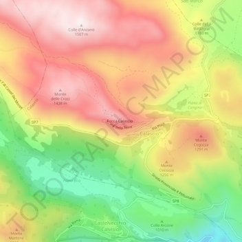
Name: Topografische Karte Rocca Calascio, Höhe, Relief.
Ort: Rocca Calascio, Calascio, L'Aquila, Abruzzo, Italy (42.30803 13.67077 42.34803 13.71077)
Durchschnittliche Höhe: 1’171 m
Minimale Höhe: 777 m
Maximale Höhe: 1’506 m
At an elevation of 1,512 metres (4,961 ft), the castle is the highest fortress in the Apennines. Built of stone and masonry exclusively for military purposes and intended only to accommodate troops and never as residence for nobles, the fortress overlooks the Plain of Navelli at one of the highest points in the ancient Barony of Carapelle.