
Topografische Karte Simpsons Farm
Interaktive Karte
Klicken Sie auf die Karte, um die Höhe anzuzeigen.
Über diese Karte
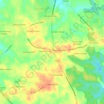
Name: Topografische Karte Simpsons Farm, Höhe, Relief.
Durchschnittliche Höhe: 38 m
Minimale Höhe: 13 m
Maximale Höhe: 60 m
Andere topografische Karten
Klicken Sie auf eine Karte, um ihre Topografie, ihre Höhe und ihr Relief anzuzeigen.
Solomons Island
United States > Maryland > Calvert County > Solomons
Solomons Island, Solomons, Calvert County, Maryland, 20688, United States
Durchschnittliche Höhe: 11 m
Mutual Consent
United States > Maryland > Calvert County
Mutual Consent, Calvert County, Maryland, 20676, United States
Durchschnittliche Höhe: 32 m
Queensberry
United States > Maryland > Calvert County > Prince Frederick > Queensberry
Queensberry, Prince Frederick, Calvert County, Maryland, 20678, United States
Durchschnittliche Höhe: 37 m