Geolokalisieren

Topografische Karte Pitigliano

Interaktive Karte

Klicken Sie auf die Karte, um die Höhe anzuzeigen.

Pitigliano

The municipality area of Pitigliano, while presenting different local situations on the basis of 'topography is characterized by rather low winter temperatures, which can occur during prolonged periods, despite the daily maximum values are often pleasing. On the contrary, in summer the heat can be very intense, though usually accompanied by low relative humidity.

Wikipedia (CC-BY-SA 3.0)

Über diese Karte

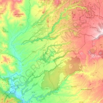
Name: Topografische Karte Pitigliano, Höhe, Relief.

Ort: Pitigliano, Unione di Comuni Montani Colline del Fiora, Grosseto, Tuscany, 58017, Italy (42.55700 11.55620 42.66287 11.79721)

Durchschnittliche Höhe: 331 m

Minimale Höhe: 98 m

Maximale Höhe: 620 m

Andere topografische Karten

Klicken Sie auf eine Karte, um ihre Topografie, ihre Höhe und ihr Relief anzuzeigen.

Stazione di Giuncarico

Italy > Tuscany > Grosseto > Castellaccia

Durchschnittliche Höhe: 39 m

Giuncarico

Italy > Tuscany > Grosseto

Durchschnittliche Höhe: 51 m

Marina di Grosseto

Italy > Tuscany > Grosseto > Grosseto

Durchschnittliche Höhe: 2 m

Albinia

Italy > Tuscany > Grosseto > Orbetello

Durchschnittliche Höhe: 1 m

San Valentino

Italy > Tuscany > Grosseto

Durchschnittliche Höhe: 457 m

Ribolla

Italy > Tuscany > Grosseto

Durchschnittliche Höhe: 74 m

Isola Rossa

Italy > Tuscany > Grosseto

Durchschnittliche Höhe: 35 m

Porto Santo Stefano

Italy > Tuscany > Grosseto > Porto Santo Stefano

Durchschnittliche Höhe: 81 m

Marsiliana

Italy > Tuscany > Grosseto

Durchschnittliche Höhe: 51 m

Case Fonte al Cerro

Italy > Tuscany > Grosseto > Puntone di Scarlino

Durchschnittliche Höhe: 36 m