
Spenden
Rüste dich für dein nächstes Abenteuer:
Als Amazon-Partner verdient diese Seite an qualifizierten Käufen, ohne dass Ihnen zusätzliche Kosten entstehen.
Topografische Karte Selayang
Klicken Sie auf die Karte, um die Höhe anzuzeigen.
Spenden
Rüste dich für dein nächstes Abenteuer:
Als Amazon-Partner verdient diese Seite an qualifizierten Käufen, ohne dass Ihnen zusätzliche Kosten entstehen.
Selayang
Given its varied topography pattern and close proximity to the Titiwangsa Mountains (Banjaran Titiwangsa), Selayang is a mix of urban and countryside sceneries. Its premier natural attraction, which is well-known across the country, is the Forest Research Institute Malaysia (FRIM), also known as FRIM Kepong. As a leading institute in tropical forestry research, it administers the sustainable management of the forest for the purpose of preservation and research. The institute dates back to 1926. This forest reserve area covers part of Kepong, Selayang (Bukit Lagong) and Rawang (Templer). Home for numerous species of flora and fauna. FRIM also functions as educational and recreational destination well equipped with infrastructures such as laboratory, information centre, sport facilities, a waterfall, river, trekking route, canopy walk, etc. The species are highly protected and visitors could see tags attached to trees displaying the names as well as quite rare animals on ground.
Spenden
Rüste dich für dein nächstes Abenteuer:
Als Amazon-Partner verdient diese Seite an qualifizierten Käufen, ohne dass Ihnen zusätzliche Kosten entstehen.
Über diese Karte
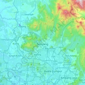
Name: Topografische Karte Selayang, Höhe, Relief.
Ort: Selayang, Selangor, 68100, Malaysia (3.09903 101.49459 3.41903 101.81459)
Durchschnittliche Höhe: 201 m
Minimale Höhe: -50 m
Maximale Höhe: 1’678 m
Spenden
Rüste dich für dein nächstes Abenteuer:
Als Amazon-Partner verdient diese Seite an qualifizierten Käufen, ohne dass Ihnen zusätzliche Kosten entstehen.