
Topografische Karte Herschel Island
Interaktive Karte
Klicken Sie auf die Karte, um die Höhe anzuzeigen.
Über diese Karte
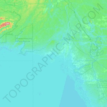
Name: Topografische Karte Herschel Island, Höhe, Relief.
Durchschnittliche Höhe: 196 m
Minimale Höhe: 171 m
Maximale Höhe: 529 m
Andere topografische Karten
Klicken Sie auf eine Karte, um ihre Topografie, ihre Höhe und ihr Relief anzuzeigen.
Memesagamesing Lake
Canada > Ontario > Unorganized Centre Parry Sound
Memesagamesing Lake, North Road, Unorganized Centre Parry Sound, Parry Sound District, Central Ontario, Ontario, Canada
Durchschnittliche Höhe: 230 m
Pickerel River
Canada > Ontario > Unorganized Centre Parry Sound
Pickerel River, Unorganized Centre Parry Sound, Parry Sound District, Ontario, Canada
Durchschnittliche Höhe: 256 m
Dollars Lake
Canada > Ontario > Unorganized Centre Parry Sound
Dollars Lake, Osprey Road, Unorganized Centre Parry Sound, Parry Sound District, Central Ontario, Ontario, Canada
Durchschnittliche Höhe: 222 m
Seagull Lake
Canada > Ontario > Unorganized Centre Parry Sound
Seagull Lake, Haussheel Road, Unorganized Centre Parry Sound, Parry Sound District, Central Ontario, Ontario, P0H 1A0, Canada
Durchschnittliche Höhe: 233 m
Key River
Canada > Ontario > Unorganized Centre Parry Sound
Key River, Unorganized Centre Parry Sound, Parry Sound District, Ontario, Canada
Durchschnittliche Höhe: 206 m
Jack's Lake
Canada > Ontario > Unorganized Centre Parry Sound
Jack's Lake, Odorizzi Road, Unorganized Centre Parry Sound, Parry Sound District, Central Ontario, Ontario, Canada
Durchschnittliche Höhe: 235 m
Britt
Canada > Ontario > Unorganized Centre Parry Sound
Britt, Unorganized Centre Parry Sound, Parry Sound District, Ontario, Canada
Durchschnittliche Höhe: 186 m
Pickerel River
Canada > Ontario > Unorganized Centre Parry Sound
Pickerel River, Unorganized Centre Parry Sound, Parry Sound District, Central Ontario, Ontario, P0H 1A0, Canada
Durchschnittliche Höhe: 247 m
Noganosh Lake
Canada > Ontario > Unorganized Centre Parry Sound
Noganosh Lake, Unorganized Centre Parry Sound, Parry Sound District, Central Ontario, Ontario, Canada
Durchschnittliche Höhe: 225 m
Byng Inlet
Canada > Ontario > Unorganized Centre Parry Sound
Byng Inlet, Unorganized Centre Parry Sound, Parry Sound District, Central Ontario, Ontario, Canada
Durchschnittliche Höhe: 183 m
Lost Channel
Canada > Ontario > Unorganized Centre Parry Sound
Lost Channel, Unorganized Centre Parry Sound, Parry Sound District, Central Ontario, Ontario, Canada
Durchschnittliche Höhe: 220 m
Stony Lake
Canada > Ontario > Unorganized Centre Parry Sound
Stony Lake, Unorganized Centre Parry Sound, Parry Sound District, Central Ontario, Ontario, Canada
Durchschnittliche Höhe: 249 m
Noganosh Lake Dam
Canada > Ontario > Unorganized Centre Parry Sound
Noganosh Lake Dam, Unorganized Centre Parry Sound, Parry Sound District, Central Ontario, Ontario, Canada
Durchschnittliche Höhe: 224 m
Key River
Canada > Ontario > Unorganized Centre Parry Sound
Key River, Unorganized Centre Parry Sound, Parry Sound District, Central Ontario, Ontario, Canada
Durchschnittliche Höhe: 213 m
Campbell's Bay
Canada > Ontario > Unorganized Centre Parry Sound
Campbell's Bay, Unorganized Centre Parry Sound, Parry Sound District, Ontario, Canada
Durchschnittliche Höhe: 203 m
The Flower Pot
Canada > Ontario > Unorganized Centre Parry Sound
The Flower Pot, Unorganized Centre Parry Sound, Parry Sound District, Ontario, Canada
Durchschnittliche Höhe: 182 m
Crystal Island
Canada > Ontario > Unorganized Centre Parry Sound
Crystal Island, Unorganized Centre Parry Sound, Parry Sound District, Ontario, Canada
Durchschnittliche Höhe: 297 m