Geolokalisieren

Topografische Karte Shropshire

Klicken Sie auf die Karte, um die Höhe anzuzeigen.

Über diese Karte

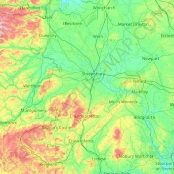
Name: Topografische Karte Shropshire, Höhe, Relief.

Ort: Shropshire, West Midlands, England, United Kingdom (52.30626 -3.23554 52.99839 -2.23290)

Durchschnittliche Höhe: 166 m

Minimale Höhe: 16 m

Maximale Höhe: 727 m

Andere topografische Karten

Klicken Sie auf eine Karte, um ihre Topografie, ihre Höhe und ihr Relief anzuzeigen.

London

United Kingdom > England > London

Durchschnittliche Höhe: 42 m

Walthamstow

United Kingdom > England > Greater London

Durchschnittliche Höhe: 21 m

Derby

United Kingdom > England > Derbyshire

Durchschnittliche Höhe: 97 m

Cambridge

United Kingdom > England > Cambridge

The city, like most of the UK, has a maritime climate highly influenced by the Gulf Stream. Located in the driest region of Britain, Cambridge's rainfall averages around 570 mm (22.44 in) per year, around half the national average, with some years occasionally falling into the semi-arid (under 500 mm (19.69…

Durchschnittliche Höhe: 18 m

City of London

United Kingdom > England > City of London > City of London

The elevation of the City ranges from sea level at the Thames to 21.6 metres (71 ft) at the junction of High Holborn and Chancery Lane. Two small but notable hills are within the historic core, Ludgate Hill to the west and Cornhill to the east. Between them ran the Walbrook, one of the many "lost" rivers or…

Durchschnittliche Höhe: 42 m

Salisbury

United Kingdom > England > Salisbury

Bishop of Salisbury Hubert Walter was instrumental in the negotiations with Saladin during the Third Crusade, but he spent little time in his diocese prior to his elevation to archbishop of Canterbury. The brothers Herbert and Richard Poore succeeded him and began planning the relocation of the cathedral into…

Durchschnittliche Höhe: 96 m

Didcot

United Kingdom > England > South Oxfordshire > Didcot

Durchschnittliche Höhe: 68 m

York

United Kingdom > England > York

Durchschnittliche Höhe: 21 m

Bedford

United Kingdom > England > Bedford

As with the rest of the United Kingdom, Bedford has a maritime climate, with a limited range of temperatures, and generally even rainfall throughout the year. The nearest Met Office weather station to Bedford is Bedford (Thurleigh) airport, about 6.5 miles (10.5 km) north of Bedford town centre at an elevation…

Durchschnittliche Höhe: 37 m

Buxton

United Kingdom > England > Derbyshire > High Peak

Durchschnittliche Höhe: 371 m

Torquay

United Kingdom > England > Torbay

Durchschnittliche Höhe: 31 m

Dean Clough

United Kingdom > England > Calderdale > Halifax

Durchschnittliche Höhe: 199 m

Bowburn

United Kingdom > England > County Durham

Durchschnittliche Höhe: 97 m

Scarborough

United Kingdom > England > North Yorkshire

The climate is temperate with mild summers and cool, windy, winters. The hottest months of the year are July and August, with temperatures reaching an average high of 17 °C and falling to 11 °C at night. The average daytime temperatures in January are 4 °C, falling to 1 °C at night. The station's elevation…

Durchschnittliche Höhe: 39 m

Slapton Sands

United Kingdom > England > Devon > South Hams > Torcross

Durchschnittliche Höhe: 28 m

Whixall

United Kingdom > England > Whixall

Durchschnittliche Höhe: 97 m

Shavington

United Kingdom > England > Cheshire East

Durchschnittliche Höhe: 57 m

Richmond Park

United Kingdom > England > Greater London

Durchschnittliche Höhe: 26 m

Ashmore Green

United Kingdom > England > West Berkshire > Cold Ash

Durchschnittliche Höhe: 108 m

Woodbridge

United Kingdom > England > Woodbridge

Durchschnittliche Höhe: 24 m

Stanhope

United Kingdom > England > County Durham

Durchschnittliche Höhe: 346 m

East Grinstead

United Kingdom > England > Mid Sussex > East Grinstead

Durchschnittliche Höhe: 96 m

Brighton

United Kingdom > England > Brighton and Hove

Durchschnittliche Höhe: 28 m

Croydon

United Kingdom > England > Greater London

Several apartment developments, for instance Altitude 25 (completed 2010), have been built in recent years, and several more are being built or planned. The construction of Saffron Square, which includes a 43-storey tower, began on Wellesley Road in 2011 and was completed in 2016. Other developments with…

Durchschnittliche Höhe: 70 m

Bromley

United Kingdom > England > Greater London

Durchschnittliche Höhe: 62 m

Peterborough

United Kingdom > England > Cambridgeshire

The local topography is flat, and in some places, the land lies below sea level, for example in parts of the Fens to the east and to the south of Peterborough. Human settlement in the area began before the Bronze Age, as can be seen at the Flag Fen archaeological site to the east of the current city centre,…

Durchschnittliche Höhe: 17 m

Ashridge

United Kingdom > England > Devon > West Devon

Durchschnittliche Höhe: 163 m

Leeds

United Kingdom > England

Lying in the eastern foothills of the Pennines, there is a significant variation in elevation within the city's built-up area. The district ranges from 1,115 feet (340 m) in the far west on the slopes of Ilkley Moor to about 33 feet (10 m) where the rivers Aire and Wharfe cross the eastern boundary. Land rises…

Durchschnittliche Höhe: 94 m

Coseley

United Kingdom > England

Durchschnittliche Höhe: 155 m

Putney

United Kingdom > England

Putney Heath is around 400 acres (160 hectares) less the nascent A3 road in size and rises to 45 metres (148 ft) above sea level. Because of its elevation, from 1796 to 1816 Putney Heath hosted a station in the shutter telegraph chain, which connected the Admiralty in London to its naval ships in Portsmouth.…

Durchschnittliche Höhe: 18 m

Birkenhead

United Kingdom > England

Durchschnittliche Höhe: 24 m

Hebden Bridge

United Kingdom > England > Calderdale

Durchschnittliche Höhe: 277 m

Chester

United Kingdom > England > Cheshire West and Chester

Durchschnittliche Höhe: 61 m

Plymouth

United Kingdom > England > Devon > Plymouth

The River Plym, which flows off Dartmoor to the north-east, forms a smaller estuary to the east of the city called Cattewater. Plymouth Sound is protected from the sea by the Plymouth Breakwater, in use since 1814. In the Sound is Drake's Island which is seen from Plymouth Hoe, a flat public area on top of…

Durchschnittliche Höhe: 81 m

High Willhays

United Kingdom > England > Devon > West Devon

High Willhays and Yes Tor are the only summits in England south of Kinder Scout in the Peak District to rise above 2,000 feet (610 m), apart from Black Mountain on the Welsh border. Before Ordnance Survey measured accurately the heights of High Willhays and Yes Tor many people believed Yes Tor was the higher…

Durchschnittliche Höhe: 512 m

Vielen Dank für die Unterstützung dieser Website ❤️
Spenden

Rüste dich für dein nächstes Abenteuer:

Als Amazon-Partner verdient diese Seite an qualifizierten Käufen, ohne dass Ihnen zusätzliche Kosten entstehen.

Rookhope

United Kingdom > England > County Durham

Durchschnittliche Höhe: 437 m

Walthamstow

United Kingdom > England

Durchschnittliche Höhe: 21 m

Edgbaston Reservoir

United Kingdom > England > Birmingham

Durchschnittliche Höhe: 155 m

Leigh

United Kingdom > England

Durchschnittliche Höhe: 34 m

Hyde Park

United Kingdom > England > London

"It consists of a screen of handsome fluted Ionic columns, with three carriage entrance archways, two-foot entrances, a lodge, etc. The extent of the whole frontage is about 107 ft (33 m). The central entrance has a bold projection: the entablature is supported by four columns; and the volutes of the capitals…

Durchschnittliche Höhe: 25 m

Crewe

United Kingdom > England > Crewe

Durchschnittliche Höhe: 53 m

Basingstoke

United Kingdom > England > Hampshire > Basingstoke and Deane

Situated in a valley through the Hampshire Downs at an average elevation of 88 metres (289 ft) Basingstoke is a major interchange between Reading, Newbury, Andover, Winchester, and Alton, and lies on the natural trade route between the southwest of England and London. The area had been something of an…

Durchschnittliche Höhe: 109 m

Hull

United Kingdom > England > Kingston upon Hull

Kingston upon Hull is on the northern bank of the Humber Estuary. The city centre is west of the River Hull and close to the Humber. The city is built upon alluvial and glacial deposits which overlie chalk rocks but the underlying chalk has no influence on the topography. The land within the city is generally…

Durchschnittliche Höhe: 21 m

Blackpool

United Kingdom > England > Borough of Blackpool

Durchschnittliche Höhe: 7 m

Durham

United Kingdom > England > County Durham

Durchschnittliche Höhe: 119 m

Stakeford

United Kingdom > England > Northumberland

Durchschnittliche Höhe: 25 m

Butser Hill

United Kingdom > England > Hampshire > East Hampshire

Durchschnittliche Höhe: 164 m

Newport

United Kingdom > England > Telford and Wrekin

Durchschnittliche Höhe: 81 m

Sawood

United Kingdom > England > Bradford > Oxenhope

Durchschnittliche Höhe: 326 m

Leigh

United Kingdom > England

Durchschnittliche Höhe: 34 m

Luddenden

United Kingdom > England > Calderdale

Durchschnittliche Höhe: 227 m

Talland Bay

United Kingdom > England > Cornwall > Porthallow

Durchschnittliche Höhe: 61 m

Tinsley Green

United Kingdom > England > West Sussex > Crawley

Durchschnittliche Höhe: 67 m

Watford

United Kingdom > England > Hertfordshire > Watford

Durchschnittliche Höhe: 83 m

Norwich

United Kingdom > England > Norfolk > Norwich

Durchschnittliche Höhe: 29 m

Crystal Palace Park

United Kingdom > England > London

Durchschnittliche Höhe: 73 m

Ashton-in-Makerfield

United Kingdom > England

Durchschnittliche Höhe: 51 m

Peaslake

United Kingdom > England > Surrey > Guildford

Durchschnittliche Höhe: 156 m

Greenwich

United Kingdom > England > Greater London

Durchschnittliche Höhe: 20 m

Mossley Hill

United Kingdom > England > Liverpool

Durchschnittliche Höhe: 36 m

Littleborough

United Kingdom > England

In the late 18th century, the low-altitude Summit Gap between Littleborough and Walsden was approved as the best route over the Pennines for the Rochdale Canal and the Manchester to Leeds railway; Hollingworth Lake was built at Littleborough's south side as a feeder reservoir to regulate the waters of the…

Durchschnittliche Höhe: 266 m

St. Mawes

United Kingdom > England > Cornwall

Durchschnittliche Höhe: 17 m

Oakworth

United Kingdom > England > Bradford

Durchschnittliche Höhe: 226 m

Camden Town

United Kingdom > England > London

Durchschnittliche Höhe: 43 m

Almondsbury

United Kingdom > England > South Gloucestershire

Durchschnittliche Höhe: 47 m

River Mersey

United Kingdom > England > Stockport

Durchschnittliche Höhe: 68 m

New Addington

United Kingdom > England > Greater London

Durchschnittliche Höhe: 134 m

Borehamwood

United Kingdom > England > Hertfordshire > Hertsmere

Durchschnittliche Höhe: 103 m

Rye

United Kingdom > England > Rother > Rye

Durchschnittliche Höhe: 12 m

Teddington

United Kingdom > England

Durchschnittliche Höhe: 17 m

Woolacombe

United Kingdom > England > Devon > North Devon

Durchschnittliche Höhe: 81 m

St Neots

United Kingdom > England > Huntingdonshire > St Neots

Durchschnittliche Höhe: 23 m

St Austell

United Kingdom > England > St Austell

Durchschnittliche Höhe: 104 m

Hinckley

United Kingdom > England > Leicestershire > Hinckley and Bosworth

Durchschnittliche Höhe: 105 m

Bicester

United Kingdom > England > Bicester

Durchschnittliche Höhe: 79 m

Stowmarket

United Kingdom > England > Stowmarket

Durchschnittliche Höhe: 52 m

Market Harborough

United Kingdom > England > Leicestershire > Harborough

Durchschnittliche Höhe: 106 m

Gainsborough

United Kingdom > England > Gainsborough

Durchschnittliche Höhe: 15 m

Stalybridge

United Kingdom > England > Tameside

Durchschnittliche Höhe: 180 m

Portsmouth

United Kingdom > England > Hampshire > Portsmouth

By road, Portsmouth lies 73.5 miles (118.3 km) from Central London, 49.5 miles (79.7 km) west of Brighton, and 22.3 miles (35.9 km) east of Southampton. Portsmouth is situated primarily on Portsea Island and is the United Kingdom's only island city, although parts of it have expanded onto the mainland. Gosport…

Durchschnittliche Höhe: 28 m

Honiton

United Kingdom > England > Honiton

Durchschnittliche Höhe: 158 m

Smethwick

United Kingdom > England > Sandwell

Durchschnittliche Höhe: 156 m

Cranbrook

United Kingdom > England > Kent > Tunbridge Wells

Durchschnittliche Höhe: 76 m

Ashton-under-Lyne

United Kingdom > England > Tameside

At 53°29′38″N 2°6′11″W / 53.49389°N 2.10306°W / 53.49389; -2.10306 (53.4941°, −2.1032°), and 160 miles (257 km) north-northwest of London, Ashton-under-Lyne stands on the north bank of the River Tame, about 35 feet (11 m) above the river. Described in Samuel Lewis's A Topographical…

Durchschnittliche Höhe: 129 m

Sherborne

United Kingdom > England > Sherborne

Durchschnittliche Höhe: 91 m

Lincoln Castle

United Kingdom > England > Lincolnshire > Lincoln

Durchschnittliche Höhe: 32 m

Foxhole

United Kingdom > England > Cornwall

Durchschnittliche Höhe: 182 m

Windermere

United Kingdom > England > Westmorland and Furness

Durchschnittliche Höhe: 147 m

Sidmouth

United Kingdom > England > Sidmouth

Durchschnittliche Höhe: 54 m

Royal Tunbridge Wells

United Kingdom > England > Kent > Tunbridge Wells

Durchschnittliche Höhe: 99 m

Aylesbury

United Kingdom > England > Aylesbury

Aylesbury is immediately southeast of the upper River Thame that flows past Thame to Dorchester on Thames and is partly sited on the two northernmost outcrops of Portland (lime)stone in England bisected by a small stream, Bear Brook which gives a relatively prominent position in relation to the terrain of all…

Durchschnittliche Höhe: 84 m

Hackney

United Kingdom > England

Durchschnittliche Höhe: 17 m

Milton Keynes

United Kingdom > England > Milton Keynes > Milton Keynes

Durchschnittliche Höhe: 81 m

Rüste dich für dein nächstes Abenteuer:

🥣Camping‑Bestecksets - Leichte Bestecksets für Touren
🧺Rucksack Regenhüllen - Schutz vor Nässe für dein Gepäck
🧥Fleecejacken für Outdoor - Wärmende Mid‑Layer für wechselhaftes Wetter
🩹Sport-Tapes - Stabilisierung von Gelenken im Gelände
☀️Sonnenschutz für Outdoor - Sonnenschutzcremes und Accessoires für lange Touren

Als Amazon-Partner verdient diese Seite an qualifizierten Käufen, ohne dass Ihnen zusätzliche Kosten entstehen.