
Spenden
Rüste dich für dein nächstes Abenteuer:
Als Amazon-Partner verdient diese Seite an qualifizierten Käufen, ohne dass Ihnen zusätzliche Kosten entstehen.
Topografische Karte Basin
Klicken Sie auf die Karte, um die Höhe anzuzeigen.
Spenden
Rüste dich für dein nächstes Abenteuer:
Als Amazon-Partner verdient diese Seite an qualifizierten Käufen, ohne dass Ihnen zusätzliche Kosten entstehen.
Über diese Karte
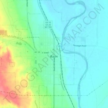
Name: Topografische Karte Basin, Höhe, Relief.
Ort: Basin, Big Horn County, Wyoming, 82410, United States (44.36395 -108.06835 44.39745 -108.02908)
Durchschnittliche Höhe: 1’188 m
Minimale Höhe: 1’166 m
Maximale Höhe: 1’244 m
Spenden
Rüste dich für dein nächstes Abenteuer:
Als Amazon-Partner verdient diese Seite an qualifizierten Käufen, ohne dass Ihnen zusätzliche Kosten entstehen.
Andere topografische Karten
Klicken Sie auf eine Karte, um ihre Topografie, ihre Höhe und ihr Relief anzuzeigen.
Cloud Peak
United States > Wyoming > Big Horn County
Located in the 189,000-acre (765 km2) Cloud Peak Wilderness within Bighorn National Forest, the peak rises to an elevation of 13,171 feet (4,015 m). It can be climbed most easily from the western side, accessed by either the Battle Park or West Tensleep trailheads, which both form 24-mile (39 km) round trips…
Durchschnittliche Höhe: 3’598 m
Cloud Peak
United States > Wyoming > Big Horn County
It rises to an elevation of 13,171 feet (4,015 m) and provides onlookers with dramatic views and vistas. The mountain can be climbed most easily from the western side, accessed by either the Battle Park or West Tensleep trail-heads and is roughly 24 miles round-trip from both. The peak is located in the…
Durchschnittliche Höhe: 3’598 m
Spenden
Rüste dich für dein nächstes Abenteuer:
Als Amazon-Partner verdient diese Seite an qualifizierten Käufen, ohne dass Ihnen zusätzliche Kosten entstehen.