Geolokalisieren

Topografische Karte Brooksville

Klicken Sie auf die Karte, um die Höhe anzuzeigen.

Brooksville

Brooksville is known for its rolling topography with elevations ranging from 100 ft to 180 ft. The highest elevation in the area is Chinsegut Hill, at 269 ft, over five and a half miles north of the city.

Wikipedia (CC-BY-SA 3.0)

Über diese Karte

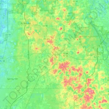
Name: Topografische Karte Brooksville, Höhe, Relief.

Ort: Brooksville, Hernando County, Florida, United States (28.48943 -82.47828 28.58760 -82.09635)

Durchschnittliche Höhe: 29 m

Minimale Höhe: 2 m

Maximale Höhe: 93 m

Andere topografische Karten

Klicken Sie auf eine Karte, um ihre Topografie, ihre Höhe und ihr Relief anzuzeigen.

Nobleton

United States > Florida > Hernando County > Nobleton

Durchschnittliche Höhe: 21 m

Spring Lake

United States > Florida > Hernando County

Spring Lake contains rolling hills ranging in elevation from 120ft to 280ft.

Durchschnittliche Höhe: 49 m

Lake Lindsey

United States > Florida > Hernando County > Lake Lindsey

Durchschnittliche Höhe: 34 m

Timber Pines

United States > Florida > Hernando County > Timber Pines

Durchschnittliche Höhe: 12 m

Spring Hill

United States > Florida > Hernando County > Spring Hill

Durchschnittliche Höhe: 18 m

Hernando Beach

United States > Florida > Hernando County

Durchschnittliche Höhe: 3 m

Pine Island

United States > Florida > Hernando County > Pine Island

Durchschnittliche Höhe: 1 m

Ridge Manor

United States > Florida > Hernando County > Brooksville > Ridge Manor

Durchschnittliche Höhe: 22 m

Camps

United States > Florida > Hernando County

Durchschnittliche Höhe: 38 m

Talisman

United States > Florida > Hernando County

Durchschnittliche Höhe: 23 m

Richloam

United States > Florida > Hernando County

Durchschnittliche Höhe: 25 m

Hill 'n Dale

United States > Florida > Hernando County

Durchschnittliche Höhe: 30 m

Ridge Manor

United States > Florida > Hernando County > Brooksville > Ridge Manor

Durchschnittliche Höhe: 22 m

Spring Hill

United States > Florida > Hernando County

Durchschnittliche Höhe: 17 m

Spring Hill

United States > Florida > Hernando County

Durchschnittliche Höhe: 18 m

Vielen Dank für die Unterstützung dieser Website ❤️
Spenden

Pine Island

United States > Florida > Hernando County

Durchschnittliche Höhe: 1 m

Weeki Wachee Gardens

United States > Florida > Hernando County

Durchschnittliche Höhe: 4 m

Spring Lake

United States > Florida > Hernando County > Spring Lake

Spring Lake contains rolling hills ranging in elevation from 120ft to 280ft.

Durchschnittliche Höhe: 49 m

Chinsegut Hill

United States > Florida > Hernando County

Durchschnittliche Höhe: 34 m

Rital

United States > Florida > Hernando County > Brooksville

Durchschnittliche Höhe: 23 m

Riverdale

United States > Florida > Hernando County

Durchschnittliche Höhe: 24 m

Spring Lake

United States > Florida > Hernando County

Spring Lake contains rolling hills ranging in elevation from 120ft to 280ft.

Durchschnittliche Höhe: 49 m

Pine Island

United States > Florida > Hernando County > Pine Island

Durchschnittliche Höhe: 1 m

Spring Hill

United States > Florida > Hernando County

Durchschnittliche Höhe: 18 m

Spring Hill

United States > Florida > Hernando County

Durchschnittliche Höhe: 18 m

Berkeley

United States > Florida > Hernando County > Berkeley

Durchschnittliche Höhe: 10 m

Timber Pines

United States > Florida > Hernando County > Timber Pines

Durchschnittliche Höhe: 12 m

Rüste dich für dein nächstes Abenteuer:

👒Sonnen‑Caps - Leichte Caps mit UV‑Schutz für Outdoor
🧦Wandersocken aus Merino - Blasenfrei wandern dank hochwertiger Merinowolle
👕Funktionsshirts fürs Wandern - Atmungsaktive Shirts für aktive Outdoor‑Touren
Sportuhren mit Barometer - Höhenmessung und Wettertrend direkt am Handgelenk
Outdoor‑GPS‑Uhren - Uhren mit GPS‑Tracking und Navigation

Als Amazon-Partner verdient diese Seite an qualifizierten Käufen, ohne dass Ihnen zusätzliche Kosten entstehen.