
Topografische Karte Dedham
Interaktive Karte
Klicken Sie auf die Karte, um die Höhe anzuzeigen.
Über diese Karte
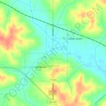
Name: Topografische Karte Dedham, Höhe, Relief.
Ort: Dedham, Carroll County, Iowa, United States (41.90243 -94.83176 41.91678 -94.81730)
Durchschnittliche Höhe: 395 m
Minimale Höhe: 371 m
Maximale Höhe: 429 m
Andere topografische Karten
Klicken Sie auf eine Karte, um ihre Topografie, ihre Höhe und ihr Relief anzuzeigen.
Ralston
United States > Iowa > Carroll County
Ralston, Carroll County, Iowa, 51459, United States
Durchschnittliche Höhe: 342 m
Coon Rapids
United States > Iowa > Carroll County
Coon Rapids, Carroll County, Iowa, United States
Durchschnittliche Höhe: 363 m
Templeton
United States > Iowa > Carroll County
Templeton, Carroll County, Iowa, United States
Durchschnittliche Höhe: 434 m
Manning
United States > Iowa > Carroll County
Manning, Carroll County, Iowa, United States
Durchschnittliche Höhe: 415 m
Glidden
United States > Iowa > Carroll County
Glidden, Carroll County, Iowa, United States
Durchschnittliche Höhe: 373 m