Geolokalisieren

Topografische Karte 郭勒木德镇

Interaktive Karte

Klicken Sie auf die Karte, um die Höhe anzuzeigen.

Über diese Karte

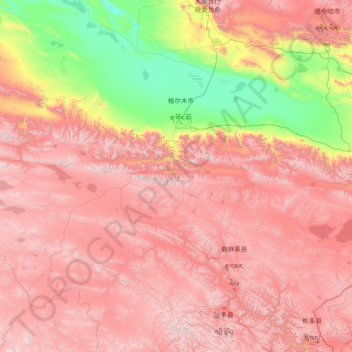
Name: Topografische Karte 郭勒木德镇, Höhe, Relief.

Ort: 郭勒木德镇, 格尔木市, 海西蒙古族藏族自治州, 青海省, 中国 (34.34675 89.80811 36.99472 95.70864)

Durchschnittliche Höhe: 4’035 m

Minimale Höhe: 2’659 m

Maximale Höhe: 5’841 m

Andere topografische Karten

Klicken Sie auf eine Karte, um ihre Topografie, ihre Höhe und ihr Relief anzuzeigen.

翡翠湖

中国 > 青海省 > 格尔木市 > 乌图美仁乡

翡翠湖, 乌图美仁乡, 格尔木市, 海西蒙古族藏族自治州, 青海省, 中国

Durchschnittliche Höhe: 4’820 m

野牛沟?

中国 > 青海省 > 格尔木市 > 郭勒木德镇

野牛沟?, 郭勒木德镇, 格尔木市, 海西蒙古族藏族自治州, 青海省, 中国

Durchschnittliche Höhe: 4’509 m

拉智村

中国 > 青海省 > 格尔木市 > 唐古拉镇

拉智村, 唐古拉镇, 格尔木市, 海西蒙古族藏族自治州, 青海省, 中国

Durchschnittliche Höhe: 4’836 m

察尔汗行政委员会

中国 > 青海省 > 格尔木市

察尔汗行政委员会, 格尔木市, 海西蒙古族藏族自治州, 青海省, 中国

Durchschnittliche Höhe: 2’954 m

唐古拉镇

中国 > 青海省 > 格尔木市

唐古拉镇, 格尔木市, 海西蒙古族藏族自治州, 青海省, 中国

Durchschnittliche Höhe: 4’756 m

冬曲

中国 > 青海省 > 格尔木市 > 雁石坪

冬曲, 雁石坪, 格尔木市, 海西蒙古族藏族自治州, 青海省, 中国

Durchschnittliche Höhe: 4’675 m

羊陇

中国 > 青海省 > 格尔木市 > 玛曲乡

羊陇, 玛曲乡, 格尔木市, 海西蒙古族藏族自治州, 青海省, 中国

Durchschnittliche Höhe: 4’943 m

达布逊湖

中国 > 青海省 > 格尔木市 > 察尔汗行政委员会

达布逊湖, 察尔汗行政委员会, 格尔木市, 海西蒙古族藏族自治州, 青海省, 中国

Durchschnittliche Höhe: 2’684 m

各拉丹冬峰

中国 > 青海省 > 格尔木市 > 雁石坪

各拉丹冬峰, 雁石坪, 格尔木市, 海西蒙古族藏族自治州, 青海省, 中国

Durchschnittliche Höhe: 6’016 m

涩聂湖

中国 > 青海省 > 格尔木市 > 察尔汗行政委员会

涩聂湖, 察尔汗行政委员会, 格尔木市, 海西蒙古族藏族自治州, 青海省, 中国

Durchschnittliche Höhe: 2’681 m

劳日特错

中国 > 青海省 > 格尔木市 > 安多县

劳日特错, 安多县, 格尔木市, 海西蒙古族藏族自治州, 青海省, 中国

Durchschnittliche Höhe: 4’997 m