
Topografische Karte North Twin Lakes
Interaktive Karte
Klicken Sie auf die Karte, um die Höhe anzuzeigen.
Über diese Karte
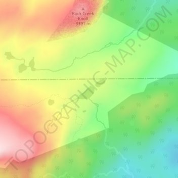
Name: Topografische Karte North Twin Lakes, Höhe, Relief.
Ort: North Twin Lakes, Albany County, Wyoming, United States (41.39124 -106.24024 41.39437 -106.23468)
Durchschnittliche Höhe: 3’258 m
Minimale Höhe: 3’107 m
Maximale Höhe: 3’429 m
Andere topografische Karten
Klicken Sie auf eine Karte, um ihre Topografie, ihre Höhe und ihr Relief anzuzeigen.
Jelm Mountain
United States > Wyoming > Albany County
Jelm Mountain, Albany County, Wyoming, 82063, United States
Durchschnittliche Höhe: 2’660 m
Laramie
United States > Wyoming > Albany County
Laramie, Albany County, Wyoming, United States
Durchschnittliche Höhe: 2’219 m
Laramie
United States > Wyoming > Albany County
Laramie, Albany County, Wyoming, United States
Durchschnittliche Höhe: 2’219 m
Centennial
United States > Wyoming > Albany County
Centennial, Albany County, Wyoming, 82055, United States
Durchschnittliche Höhe: 2’577 m
Jelm
United States > Wyoming > Albany County
Jelm, Albany County, Wyoming, United States
Durchschnittliche Höhe: 2’422 m
PhinDeli Town Buford
United States > Wyoming > Albany County
PhinDeli Town Buford, Albany County, Wyoming, United States
Durchschnittliche Höhe: 2’386 m
Black Mountain
United States > Wyoming > Albany County
Black Mountain, Albany County, Wyoming, United States
Durchschnittliche Höhe: 2’172 m
Laramie
United States > Wyoming > Albany County > Laramie
Laramie, Albany County, Wyoming, 82070, United States
Durchschnittliche Höhe: 2’299 m
Medicine Bow Peak
United States > Wyoming > Albany County
Medicine Bow Peak, Albany County, Wyoming, United States
Durchschnittliche Höhe: 3’396 m