
Topografische Karte Scopello
Interaktive Karte
Klicken Sie auf die Karte, um die Höhe anzuzeigen.
Über diese Karte
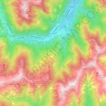
Name: Topografische Karte Scopello, Höhe, Relief.
Ort: Scopello, Vercelli, Piemont, 13028, Italien (45.71875 8.05898 45.79749 8.14081)
Durchschnittliche Höhe: 1’256 m
Minimale Höhe: 595 m
Maximale Höhe: 1’935 m
Andere topografische Karten
Klicken Sie auf eine Karte, um ihre Topografie, ihre Höhe und ihr Relief anzuzeigen.