
Spenden
Rüste dich für dein nächstes Abenteuer:
Als Amazon-Partner verdient diese Seite an qualifizierten Käufen, ohne dass Ihnen zusätzliche Kosten entstehen.
Topografische Karte Northfield
Klicken Sie auf die Karte, um die Höhe anzuzeigen.
Spenden
Rüste dich für dein nächstes Abenteuer:
Als Amazon-Partner verdient diese Seite an qualifizierten Käufen, ohne dass Ihnen zusätzliche Kosten entstehen.
Über diese Karte
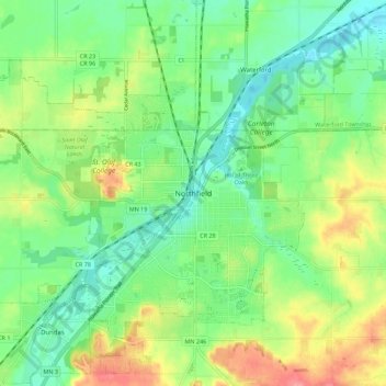
Name: Topografische Karte Northfield, Höhe, Relief.
Durchschnittliche Höhe: 300 m
Minimale Höhe: 269 m
Maximale Höhe: 352 m
Spenden
Rüste dich für dein nächstes Abenteuer:
Als Amazon-Partner verdient diese Seite an qualifizierten Käufen, ohne dass Ihnen zusätzliche Kosten entstehen.
Andere topografische Karten
Klicken Sie auf eine Karte, um ihre Topografie, ihre Höhe und ihr Relief anzuzeigen.
Northfield
United States > Minnesota > Rice County
According to the United States Census Bureau, the city has an area of 8.61 square miles (22.30 km2); 8.56 square miles (22.17 km2) is land and 0.05 square miles (0.13 km2) is water. The peak elevation is about 912 feet.
Durchschnittliche Höhe: 298 m
Dundas
United States > Minnesota > Rice County
According to the United States Census Bureau, the city has a total area of 1.92 square miles (4.97 km2), all land. The Cannon River passes through the center of town. The latitude of Dundas is 44.429N. The longitude is 93.204W. Dundas' elevation is 932 feet above sea level.
Durchschnittliche Höhe: 298 m
Spenden
Rüste dich für dein nächstes Abenteuer:
Als Amazon-Partner verdient diese Seite an qualifizierten Käufen, ohne dass Ihnen zusätzliche Kosten entstehen.
Northfield
United States > Minnesota > Rice County
According to the United States Census Bureau, the city has an area of 8.61 square miles (22.30 km2); 8.56 square miles (22.17 km2) is land and 0.05 square miles (0.13 km2) is water. The peak elevation is about 912 ft (278 m).
Durchschnittliche Höhe: 298 m
Dundas
United States > Minnesota > Rice County
According to the United States Census Bureau, the city has a total area of 1.92 square miles (4.97 km2), all land. The Cannon River passes through the center of town. The latitude of Dundas is 44.429N. The longitude is 93.204W. Dundas' elevation is 932 feet above sea level.
Durchschnittliche Höhe: 298 m
Northfield
United States > Minnesota > Rice County
According to the United States Census Bureau, the city has an area of 8.61 square miles (22.30 km2); 8.56 square miles (22.17 km2) is land and 0.05 square miles (0.13 km2) is water. The peak elevation is about 912 ft (278 m).
Durchschnittliche Höhe: 298 m
Spenden
Rüste dich für dein nächstes Abenteuer:
Als Amazon-Partner verdient diese Seite an qualifizierten Käufen, ohne dass Ihnen zusätzliche Kosten entstehen.
Dundas
United States > Minnesota > Rice County
According to the United States Census Bureau, the city has a total area of 1.92 square miles (4.97 km2), all land. The Cannon River passes through the center of town. The latitude of Dundas is 44.429N. The longitude is 93.204W. Dundas' elevation is 932 feet above sea level.
Durchschnittliche Höhe: 298 m
Spenden
Rüste dich für dein nächstes Abenteuer:
Als Amazon-Partner verdient diese Seite an qualifizierten Käufen, ohne dass Ihnen zusätzliche Kosten entstehen.