
Topografische Karte Kerlavret
Interaktive Karte
Klicken Sie auf die Karte, um die Höhe anzuzeigen.
Über diese Karte
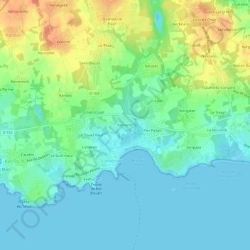
Name: Topografische Karte Kerlavret, Höhe, Relief.
Durchschnittliche Höhe: 14 m
Minimale Höhe: -1 m
Maximale Höhe: 41 m
Andere topografische Karten
Klicken Sie auf eine Karte, um ihre Topografie, ihre Höhe und ihr Relief anzuzeigen.
Kergourgan
France > Bretagne > Morbihan > Plœmeur
Kergourgan, Plœmeur, Lorient, Morbihan, Bretagne, France métropolitaine, 56270, France
Durchschnittliche Höhe: 30 m
Le Douet Neuf
France > Bretagne > Morbihan > Plœmeur
Le Douet Neuf, Plœmeur, Lorient, Morbihan, Bretagne, France métropolitaine, 56270, France
Durchschnittliche Höhe: 12 m
Douar Guenn
France > Bretagne > Morbihan > Plœmeur
Douar Guenn, Plœmeur, Lorient, Morbihan, Bretagne, France métropolitaine, 56270, France
Durchschnittliche Höhe: 28 m
Le Fort-Bloqué
France > Bretagne > Morbihan > Plœmeur
Le Fort-Bloqué, Plœmeur, Lorient, Morbihan, Bretagne, France métropolitaine, 56270, France
Durchschnittliche Höhe: 7 m
Fort-Bloqué
France > Bretagne > Morbihan > Plœmeur > Le Fort-Bloqué
Fort-Bloqué, Allée des Touristes, Le Fort-Bloqué, Plœmeur, Lorient, Morbihan, Bretagne, France métropolitaine, 56270, France
Durchschnittliche Höhe: 4 m
Kerduellic
France > Bretagne > Morbihan > Plœmeur > Kerduellic
Kerduellic, Plœmeur, Lorient, Morbihan, Bretagne, France métropolitaine, 56270, France
Durchschnittliche Höhe: 31 m
Saint-Adrien
France > Bretagne > Morbihan > Plœmeur > Le Fort-Bloqué > Saint-Adrien
Saint-Adrien, Le Fort-Bloqué, Plœmeur, Lorient, Morbihan, Bretagne, France métropolitaine, 56270, France
Durchschnittliche Höhe: 10 m
Quéhello le Floch
France > Bretagne > Morbihan > Plœmeur > Quéhello le Floch
Quéhello le Floch, Plœmeur, Lorient, Morbihan, Bretagne, France métropolitaine, 56270, France
Durchschnittliche Höhe: 26 m
Le Courégant
France > Bretagne > Morbihan > Plœmeur
Le Courégant, Plœmeur, Lorient, Morbihan, Bretagne, France métropolitaine, 56270, France
Durchschnittliche Höhe: 9 m