
Topografische Karte Lafayette
Interaktive Karte
Klicken Sie auf die Karte, um die Höhe anzuzeigen.
Über diese Karte
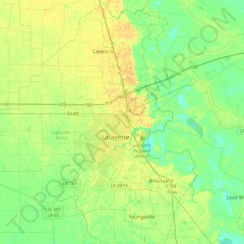
Name: Topografische Karte Lafayette, Höhe, Relief.
Ort: Lafayette, Lafayette Parish, Louisiana, 70502, United States (30.04433 -92.18988 30.36433 -91.86988)
Durchschnittliche Höhe: 9 m
Minimale Höhe: 0 m
Maximale Höhe: 21 m
Lafayette lies approximately 135 miles (217 km) from New Orleans, 59 miles (95 km) from the state capital of Baton Rouge, 75 miles (121 km) from Lake Charles, and 89 miles (143 km) from Alexandria. The city has an elevation ranging from 36 feet (11.0 m) to 49 feet (15 m) above sea level. According to the United States Census Bureau, the city has a total area of 55.65 square miles (144.1 km2), of which 55.57 square miles (143.9 km2) is land and 0.08 sq mi (0.21 km2) (0.19 percent) is covered by water.
Andere topografische Karten
Klicken Sie auf eine Karte, um ihre Topografie, ihre Höhe und ihr Relief anzuzeigen.
Arbolada Addition
United States > Louisiana > Lafayette Parish > Lafayette
Arbolada Addition, Lafayette, Lafayette Parish, Louisiana, 70504, United States
Durchschnittliche Höhe: 14 m