
Topografische Karte Douglasville
Interaktive Karte
Klicken Sie auf die Karte, um die Höhe anzuzeigen.
Über diese Karte
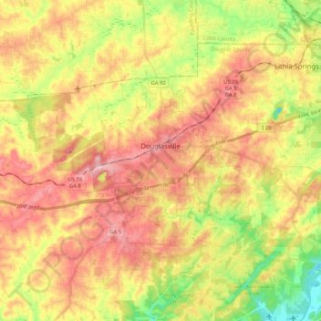
Name: Topografische Karte Douglasville, Höhe, Relief.
Ort: Douglasville, Douglas County, Georgia, 30133, United States (33.69597 -84.79482 33.79098 -84.58940)
Durchschnittliche Höhe: 310 m
Minimale Höhe: 218 m
Maximale Höhe: 389 m
Located along a natural rise in the topography, Douglasville was originally known as "Skint Chestnut." The name was derived from a large tree used by Native Americans as a landmark; it was stripped of its bark so as to be more conspicuous.