Topografische Karte Jingtai County
Klicken Sie auf die Karte, um die Höhe anzuzeigen.
Jingtai County
The county is largely hilly and mountainous, with an elevation ranging from 1,276 metres (4,186 ft) to 3,321 metres (10,896 ft) above sea level. The county is home to a number of prominent tourist sites, such as the Yellow River Stone Forest, Yongtai Fortress, and other locations.
Über diese Karte
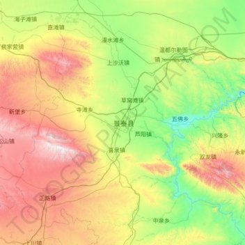
Name: Topografische Karte Jingtai County, Höhe, Relief.
Ort: Jingtai County, Baiyin Municipality, Gansu, China (36.72413 103.54506 37.63195 104.71512)
Durchschnittliche Höhe: 1’918 m
Minimale Höhe: 1’280 m
Maximale Höhe: 3’298 m
Andere topografische Karten
Klicken Sie auf eine Karte, um ihre Topografie, ihre Höhe und ihr Relief anzuzeigen.


Zhangye Danxia National Geological Park
China > Gansu > Linze County > Nantai
Durchschnittliche Höhe: 1’759 m

龚岔牧饲点
China > Gansu > Subei Mongol Autonomous County > Shibaocheng > 鹰嘴山村
Durchschnittliche Höhe: 2’181 m

Gannan
China > Gansu > Hezuo City > Tongqin
Gannan, as illustrated by this chart for Xiahe, has an alpine subarctic climate (Köppen Dwc) that grades into an alpine climate (ETH) at the highest elevations. The climate is characterised by mild, rainy summers and frigid, but dry and sunny, winters.
Durchschnittliche Höhe: 3’075 m
Mount Qilian
China > Gansu > Sunan Yugur Autonomous County > Qifeng Tibetan Ethnic Township
Durchschnittliche Höhe: 5’071 m


Junma Sichang Qilian
China > Gansu > Shandan County > Shandan horse breeding area
Durchschnittliche Höhe: 2’558 m