Topografische Karte Wilson
Interaktive Karte
Klicken Sie auf die Karte, um die Höhe anzuzeigen.
Über diese Karte
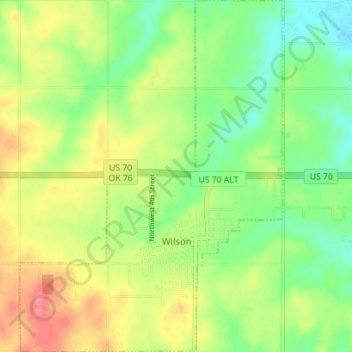
Name: Topografische Karte Wilson, Höhe, Relief.
Ort: Wilson, Carter County, Oklahoma, 73463, United States (34.14377 -97.45725 34.20185 -97.40458)
Durchschnittliche Höhe: 286 m
Minimale Höhe: 254 m
Maximale Höhe: 326 m
Andere topografische Karten
Klicken Sie auf eine Karte, um ihre Topografie, ihre Höhe und ihr Relief anzuzeigen.
Pooleville
United States > Oklahoma > Carter County
Pooleville, Carter County, Oklahoma, United States
Durchschnittliche Höhe: 318 m
Fox
United States > Oklahoma > Carter County
Fox, Carter County, Oklahoma, 73435, United States
Durchschnittliche Höhe: 299 m
Milo
United States > Oklahoma > Carter County
Milo, Carter County, Oklahoma, United States
Durchschnittliche Höhe: 276 m
Gene Autry
United States > Oklahoma > Carter County
Gene Autry, Carter County, Oklahoma, 73436, United States
Durchschnittliche Höhe: 231 m
Springer
United States > Oklahoma > Carter County
Springer, Carter County, Oklahoma, 73458, United States
Durchschnittliche Höhe: 259 m
Graham
United States > Oklahoma > Carter County
Graham, Carter County, Oklahoma, 73437, United States
Durchschnittliche Höhe: 287 m
Tussy
United States > Oklahoma > Carter County
Tussy, Carter County, Oklahoma, 73488, United States
Durchschnittliche Höhe: 297 m
Tatums
United States > Oklahoma > Carter County
Tatums, Carter County, Oklahoma, 73487, United States
Durchschnittliche Höhe: 297 m
Dickson
United States > Oklahoma > Carter County
Dickson, Carter County, Oklahoma, United States
Durchschnittliche Höhe: 246 m
Ratliff City
United States > Oklahoma > Carter County
Ratliff City, Carter County, Oklahoma, United States
Durchschnittliche Höhe: 315 m
Ardmore
United States > Oklahoma > Carter County
Ardmore, Carter County, Oklahoma, United States
Durchschnittliche Höhe: 258 m
Lake Murray
United States > Oklahoma > Carter County > Ardmore
Lake Murray, Ardmore, Carter County, Oklahoma, United States
Durchschnittliche Höhe: 240 m
Lone Grove
United States > Oklahoma > Carter County
Lone Grove, Carter County, Oklahoma, 73443, United States
Durchschnittliche Höhe: 274 m
Healdton
United States > Oklahoma > Carter County
Healdton, Carter County, Oklahoma, 73438, United States
Durchschnittliche Höhe: 289 m