
Topografische Karte King Edward Park
Interaktive Karte
Klicken Sie auf die Karte, um die Höhe anzuzeigen.
Über diese Karte
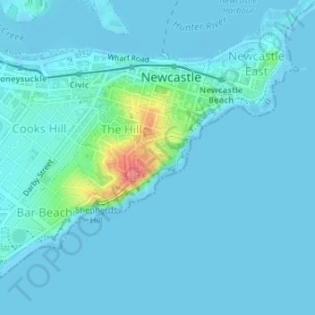
Name: Topografische Karte King Edward Park, Höhe, Relief.
Durchschnittliche Höhe: 8 m
Minimale Höhe: -1 m
Maximale Höhe: 76 m
Andere topografische Karten
Klicken Sie auf eine Karte, um ihre Topografie, ihre Höhe und ihr Relief anzuzeigen.
Kotara
Australia > New South Wales > Newcastle
Kotara, Newcastle, Newcastle-Maitland, Newcastle City Council, New South Wales, 2289, Australia
Durchschnittliche Höhe: 68 m
Newcastle
Australia > New South Wales > Newcastle
Newcastle, Newcastle-Maitland, Newcastle City Council, New South Wales, 2300, Australia
Durchschnittliche Höhe: 5 m
Warners Bay
Australia > New South Wales > Newcastle
Warners Bay, Newcastle, Newcastle-Maitland, Lake Macquarie City Council, New South Wales, 2282, Australia
Durchschnittliche Höhe: 32 m
Newcastle
Australia > New South Wales > Newcastle
Belmont, Newcastle, Newcastle-Maitland, Lake Macquarie City Council, New South Wales, 2280, Australia
Durchschnittliche Höhe: 14 m
Lambton
Australia > New South Wales > Newcastle
Lambton, Newcastle, Newcastle-Maitland, Newcastle City Council, New South Wales, 2299, Australia
Durchschnittliche Höhe: 37 m
Speers Point
Australia > New South Wales > Newcastle
Speers Point, Newcastle, Newcastle-Maitland, Lake Macquarie City Council, New South Wales, 2284, Australia
Durchschnittliche Höhe: 27 m
Killingworth
Australia > New South Wales > Newcastle
Killingworth, Newcastle, Newcastle-Maitland, Lake Macquarie City Council, New South Wales, 2278, Australia
Durchschnittliche Höhe: 60 m