
Topografische Karte Village of Hamilton
Interaktive Karte
Klicken Sie auf die Karte, um die Höhe anzuzeigen.
Über diese Karte
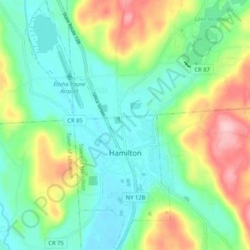
Name: Topografische Karte Village of Hamilton, Höhe, Relief.
Durchschnittliche Höhe: 386 m
Minimale Höhe: 331 m
Maximale Höhe: 502 m
The village, located at 42°49′32″N 75°32′40″W / 42.82556°N 75.54444°W / 42.82556; -75.54444 (42.825646, -75.544673), lies in the Chenango Valley, just south of the headwaters of the Chenango River. Northeast of the village is the river Payne Brook, which starts at Lake Moraine and travels through the village before converging with the Chenango River. The village is approximately 40 miles (64 km) southeast of Syracuse and 30 miles (48 km) southwest of Utica. The elevation of the village's municipal airport (Hamilton Municipal Airport) is approximately 1,100 feet (340 m) above sea level.
Andere topografische Karten
Klicken Sie auf eine Karte, um ihre Topografie, ihre Höhe und ihr Relief anzuzeigen.
Village of Earlville
United States > New York > Madison County > Town of Hamilton
Village of Earlville, Town of Hamilton, Madison County, New York, United States
Durchschnittliche Höhe: 342 m