
Spenden
Rüste dich für dein nächstes Abenteuer:
Als Amazon-Partner verdient diese Seite an qualifizierten Käufen, ohne dass Ihnen zusätzliche Kosten entstehen.
Topografische Karte Kiawah Island
Klicken Sie auf die Karte, um die Höhe anzuzeigen.
Spenden
Rüste dich für dein nächstes Abenteuer:
Als Amazon-Partner verdient diese Seite an qualifizierten Käufen, ohne dass Ihnen zusätzliche Kosten entstehen.
Kiawah Island
Kiawah Island features a low-lying, sandy topography typical of barrier islands along the southeastern coast of the United States. The island's average elevation is about 10 feet above sea level, with some areas reaching slightly higher. Its terrain is characterized by broad, flat beaches that gently slope into the Atlantic Ocean, interspersed with lush maritime forests and salt marshes. These ecosystems create a rich biodiversity, supporting a variety of wildlife. The landscape includes both freshwater lagoons and saltwater estuaries, contributing to its unique ecological environment. Overall, Kiawah Island's topography offers a serene natural setting that enhances its appeal as a vacation destination.
Spenden
Rüste dich für dein nächstes Abenteuer:
Als Amazon-Partner verdient diese Seite an qualifizierten Käufen, ohne dass Ihnen zusätzliche Kosten entstehen.
Über diese Karte
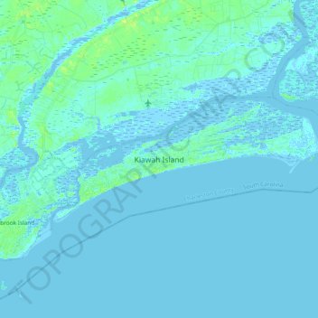
Name: Topografische Karte Kiawah Island, Höhe, Relief.
Durchschnittliche Höhe: 2 m
Minimale Höhe: -3 m
Maximale Höhe: 13 m
Spenden
Rüste dich für dein nächstes Abenteuer:
Als Amazon-Partner verdient diese Seite an qualifizierten Käufen, ohne dass Ihnen zusätzliche Kosten entstehen.
Andere topografische Karten
Klicken Sie auf eine Karte, um ihre Topografie, ihre Höhe und ihr Relief anzuzeigen.
Hobcaw Point
United States > South Carolina > Charleston County > Mount Pleasant
Durchschnittliche Höhe: 4 m
Spenden
Rüste dich für dein nächstes Abenteuer:
Als Amazon-Partner verdient diese Seite an qualifizierten Käufen, ohne dass Ihnen zusätzliche Kosten entstehen.
Saint Andrews Heights
United States > South Carolina > Charleston County > Charleston
Durchschnittliche Höhe: 5 m
Pinewood Vista
United States > South Carolina > Charleston County > North Charleston
Durchschnittliche Höhe: 9 m
Jamestown Estates
United States > South Carolina > Charleston County > James Island
Durchschnittliche Höhe: 4 m
Spenden
Rüste dich für dein nächstes Abenteuer:
Als Amazon-Partner verdient diese Seite an qualifizierten Käufen, ohne dass Ihnen zusätzliche Kosten entstehen.
Marsh Cove
United States > South Carolina > Charleston County > Charleston
Durchschnittliche Höhe: 4 m
Brook Green Meadow
United States > South Carolina > Charleston County > Mount Pleasant
Durchschnittliche Höhe: 4 m
Spenden
Rüste dich für dein nächstes Abenteuer:
Als Amazon-Partner verdient diese Seite an qualifizierten Käufen, ohne dass Ihnen zusätzliche Kosten entstehen.
Westchester
United States > South Carolina > Charleston County > Charleston
Durchschnittliche Höhe: 4 m
Spenden
Rüste dich für dein nächstes Abenteuer:
Als Amazon-Partner verdient diese Seite an qualifizierten Käufen, ohne dass Ihnen zusätzliche Kosten entstehen.
Wild Dunes
United States > South Carolina > Charleston County > Isle of Palms
Durchschnittliche Höhe: 1 m
Spenden
Rüste dich für dein nächstes Abenteuer:
Als Amazon-Partner verdient diese Seite an qualifizierten Käufen, ohne dass Ihnen zusätzliche Kosten entstehen.
Palmetto Fort
United States > South Carolina > Charleston County > Mount Pleasant
Durchschnittliche Höhe: 4 m
Camp Saint Christopher
United States > South Carolina > Charleston County > Seabrook Island
Durchschnittliche Höhe: 2 m
Remleys Point
United States > South Carolina > Charleston County > Mount Pleasant
Durchschnittliche Höhe: 4 m
Spenden
Rüste dich für dein nächstes Abenteuer:
Als Amazon-Partner verdient diese Seite an qualifizierten Käufen, ohne dass Ihnen zusätzliche Kosten entstehen.
Three Trees
United States > South Carolina > Charleston County > Charleston
Durchschnittliche Höhe: 3 m
North Charleston Wannamaker County Park
United States > South Carolina > Charleston County > North Charleston
Durchschnittliche Höhe: 8 m
Spenden
Rüste dich für dein nächstes Abenteuer:
Als Amazon-Partner verdient diese Seite an qualifizierten Käufen, ohne dass Ihnen zusätzliche Kosten entstehen.
Forest Park
United States > South Carolina > Charleston County > Charleston > Maryville
Durchschnittliche Höhe: 5 m
Wando Estates
United States > South Carolina > Charleston County > Mount Pleasant
Durchschnittliche Höhe: 5 m
Westchester
United States > South Carolina > Charleston County > Charleston
Durchschnittliche Höhe: 4 m
Spenden
Rüste dich für dein nächstes Abenteuer:
Als Amazon-Partner verdient diese Seite an qualifizierten Käufen, ohne dass Ihnen zusätzliche Kosten entstehen.
Kings Acres
United States > South Carolina > Charleston County > Charleston
Durchschnittliche Höhe: 4 m
Spenden
Rüste dich für dein nächstes Abenteuer:
Als Amazon-Partner verdient diese Seite an qualifizierten Käufen, ohne dass Ihnen zusätzliche Kosten entstehen.
Heritage
United States > South Carolina > Charleston County > Mount Pleasant
Durchschnittliche Höhe: 4 m
Liberty Hill
United States > South Carolina > Charleston County > North Charleston
Durchschnittliche Höhe: 7 m
Spenden
Rüste dich für dein nächstes Abenteuer:
Als Amazon-Partner verdient diese Seite an qualifizierten Käufen, ohne dass Ihnen zusätzliche Kosten entstehen.
Forest Trail
United States > South Carolina > Charleston County > Isle of Palms
Durchschnittliche Höhe: 1 m
Saint Andrews Heights
United States > South Carolina > Charleston County > Charleston
Durchschnittliche Höhe: 5 m
Ashley Junction
United States > South Carolina > Charleston County > North Charleston
Durchschnittliche Höhe: 7 m
Spenden
Rüste dich für dein nächstes Abenteuer:
Als Amazon-Partner verdient diese Seite an qualifizierten Käufen, ohne dass Ihnen zusätzliche Kosten entstehen.
Moss Park
United States > South Carolina > Charleston County > Mount Pleasant
Durchschnittliche Höhe: 4 m
Camp Saint Christopher
United States > South Carolina > Charleston County > Seabrook Island
Durchschnittliche Höhe: 2 m
Deerwood Heights
United States > South Carolina > Charleston County > North Charleston
Durchschnittliche Höhe: 8 m
Spenden
Rüste dich für dein nächstes Abenteuer:
Als Amazon-Partner verdient diese Seite an qualifizierten Käufen, ohne dass Ihnen zusätzliche Kosten entstehen.
Northwood Estates
United States > South Carolina > Charleston County > North Charleston > Northwood Estates
Durchschnittliche Höhe: 8 m
North Charleston
United States > South Carolina > Charleston County > North Charleston
Durchschnittliche Höhe: 5 m
Marlborough
United States > South Carolina > Charleston County > Charleston
Durchschnittliche Höhe: 4 m
Spenden
Rüste dich für dein nächstes Abenteuer:
Als Amazon-Partner verdient diese Seite an qualifizierten Käufen, ohne dass Ihnen zusätzliche Kosten entstehen.
Country Club Estates
United States > South Carolina > Charleston County > Charleston
Durchschnittliche Höhe: 3 m