
Topografische Karte Ludlow
Interaktive Karte
Klicken Sie auf die Karte, um die Höhe anzuzeigen.
Über diese Karte
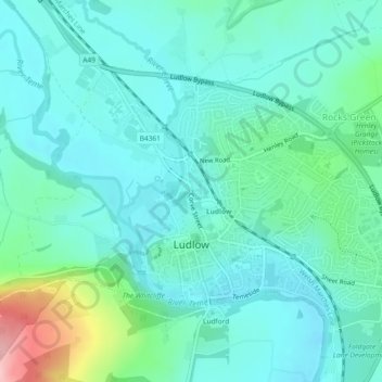
Name: Topografische Karte Ludlow, Höhe, Relief.
Ort: Ludlow, Shropshire, England, United Kingdom (52.36254 -2.74025 52.38117 -2.69417)
Durchschnittliche Höhe: 108 m
Minimale Höhe: 72 m
Maximale Höhe: 254 m
During the 12th century, the planned town of Ludlow was formed, in stages, the town providing a useful source of income for successive Marcher Lords, based on rents, fines, and tolls. They developed the town on a regular grid pattern, although this was adapted somewhat to match the local topography, from the late 11th century through the 12th century. The first laid street was along the ridge of the hilltop, what is now Castle Square, High Street and King Street. This formed a wide market place (later in-filled by buildings in places) running from the castle gates east across to St Laurence's and the Bull Ring, itself located on the ancient north–south road, now called Corve Street to the north and Old Street to the south. The wide Mill and Broad Streets were added later, as part of a southern grid plan of streets and burgage plots filling the area bounded by Dinham, the new High Street market, Old Street and the Teme to the south. Originally, Old Street ran down to a ford which took the ancient route south across to Ludford. A bridge was constructed (possibly by Josce de Dinan) at the foot of Broad Street, upstream of the ford, which then replaced the ford; its 15th-century replacement is the present-day Ludford Bridge.
Andere topografische Karten
Klicken Sie auf eine Karte, um ihre Topografie, ihre Höhe und ihr Relief anzuzeigen.
Alveley
United Kingdom > England > Shropshire
Alveley, Shropshire, England, WV15 6PQ, United Kingdom
Durchschnittliche Höhe: 102 m
Selattyn
United Kingdom > England > Shropshire
Selattyn, Shropshire, England, SY10 7EZ, United Kingdom
Durchschnittliche Höhe: 242 m
Walford
United Kingdom > England > Shropshire
Walford, Baschurch, Shropshire, England, SY4 2HR, United Kingdom
Durchschnittliche Höhe: 83 m
Church Stretton
United Kingdom > England > Shropshire
Church Stretton, Shropshire, England, United Kingdom
Durchschnittliche Höhe: 280 m
Lawn Hill
United Kingdom > England > Shropshire > Church Pulverbatch
Lawn Hill, Church Pulverbatch, Shropshire, England, SY5 8EQ, United Kingdom
Durchschnittliche Höhe: 228 m
Broseley
United Kingdom > England > Shropshire
Broseley, Shropshire, England, United Kingdom
Durchschnittliche Höhe: 142 m
Cedars of Lebanon
United Kingdom > England > Shropshire > Atcham
Cedars of Lebanon, Atcham, Shropshire, England, United Kingdom
Durchschnittliche Höhe: 52 m
Romsley
United Kingdom > England > Shropshire
Romsley, Shropshire, England, United Kingdom
Durchschnittliche Höhe: 134 m
Oswestry
United Kingdom > England > Shropshire
Oswestry, Shropshire, England, SY11 1PX, United Kingdom
Durchschnittliche Höhe: 158 m
Snailbeach
United Kingdom > England > Shropshire
Snailbeach, Shropshire, England, SY5 0NX, United Kingdom
Durchschnittliche Höhe: 248 m
Much Wenlock
United Kingdom > England > Shropshire
Much Wenlock, Shropshire, West Midlands, England, United Kingdom
Durchschnittliche Höhe: 159 m
Shrewsbury
United Kingdom > England > Shropshire
Shrewsbury, Shropshire, England, United Kingdom
Durchschnittliche Höhe: 69 m
Ellesmere
United Kingdom > England > Shropshire > Ellesmere
Ellesmere, Shropshire, England, SY12 0EQ, United Kingdom
Durchschnittliche Höhe: 94 m
Wooton
United Kingdom > England > Shropshire
Wooton, Oswestry Rural, Shropshire, England, SY11 4LH, United Kingdom
Durchschnittliche Höhe: 90 m
Craven Arms
United Kingdom > England > Shropshire
Craven Arms, Shropshire, England, United Kingdom
Durchschnittliche Höhe: 182 m