
Spenden
Rüste dich für dein nächstes Abenteuer:
Als Amazon-Partner verdient diese Seite an qualifizierten Käufen, ohne dass Ihnen zusätzliche Kosten entstehen.
Topografische Karte Old Fort
Klicken Sie auf die Karte, um die Höhe anzuzeigen.
Spenden
Rüste dich für dein nächstes Abenteuer:
Als Amazon-Partner verdient diese Seite an qualifizierten Käufen, ohne dass Ihnen zusätzliche Kosten entstehen.
Über diese Karte
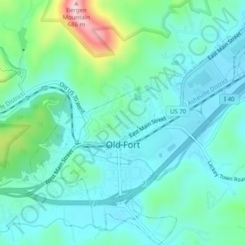
Name: Topografische Karte Old Fort, Höhe, Relief.
Ort: Old Fort, McDowell County, North Carolina, United States (35.61726 -82.19397 35.64572 -82.15928)
Durchschnittliche Höhe: 474 m
Minimale Höhe: 422 m
Maximale Höhe: 672 m
Spenden
Rüste dich für dein nächstes Abenteuer:
Als Amazon-Partner verdient diese Seite an qualifizierten Käufen, ohne dass Ihnen zusätzliche Kosten entstehen.
Andere topografische Karten
Klicken Sie auf eine Karte, um ihre Topografie, ihre Höhe und ihr Relief anzuzeigen.
Little Switzerland
United States > North Carolina > McDowell County
Little Switzerland is an unincorporated community in McDowell and Mitchell counties of North Carolina, United States. It is located along North Carolina Highway 226A (NC 226A) off the Blue Ridge Parkway, directly north of Marion and south of Spruce Pine. The elevation is 3,468 feet (1,057 m) above sea level.
Durchschnittliche Höhe: 935 m
Spenden
Rüste dich für dein nächstes Abenteuer:
Als Amazon-Partner verdient diese Seite an qualifizierten Käufen, ohne dass Ihnen zusätzliche Kosten entstehen.
Structure Number Six B Dam
United States > North Carolina > McDowell County
Durchschnittliche Höhe: 471 m
Spenden
Rüste dich für dein nächstes Abenteuer:
Als Amazon-Partner verdient diese Seite an qualifizierten Käufen, ohne dass Ihnen zusätzliche Kosten entstehen.
Spenden
Rüste dich für dein nächstes Abenteuer:
Als Amazon-Partner verdient diese Seite an qualifizierten Käufen, ohne dass Ihnen zusätzliche Kosten entstehen.
Little Switzerland
United States > North Carolina > McDowell County
Little Switzerland is an unincorporated community in McDowell and Mitchell counties of North Carolina, United States. It is located along North Carolina Highway 226A (NC 226A) off the Blue Ridge Parkway, directly north of Marion and south of Spruce Pine. The elevation is 3,468 feet (1,057 m) above sea level.
Durchschnittliche Höhe: 935 m