
Spenden
Rüste dich für dein nächstes Abenteuer:
Als Amazon-Partner verdient diese Seite an qualifizierten Käufen, ohne dass Ihnen zusätzliche Kosten entstehen.
Topografische Karte Bute Inlet
Klicken Sie auf die Karte, um die Höhe anzuzeigen.
Spenden
Rüste dich für dein nächstes Abenteuer:
Als Amazon-Partner verdient diese Seite an qualifizierten Käufen, ohne dass Ihnen zusätzliche Kosten entstehen.
Bute Inlet
The Bute Inlet route was later considered for the mainline of the Canadian Pacific Railway (CPR), which would have seen extensive blasting down the west shore of the inlet and a series of bridges to reach Vancouver Island near Campbell River via Seymour Narrows. This route was passed over in favour of the Fraser Canyon route to a new port-city at Burrard Inlet, which was to become the city of Port Moody. The residual political impact of the Chilcotin War was one factor dissuading the CPR from using Bute Inlet; the other was the severe grades required in the canyon of the Homathko River in order to reach the elevation of the Chilcotin Plateau on the inland side of the Coast Range, as well as the cost of blasting along the inlet and the deep water bridges needed below it.
Spenden
Rüste dich für dein nächstes Abenteuer:
Als Amazon-Partner verdient diese Seite an qualifizierten Käufen, ohne dass Ihnen zusätzliche Kosten entstehen.
Über diese Karte
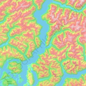
Name: Topografische Karte Bute Inlet, Höhe, Relief.
Durchschnittliche Höhe: 921 m
Minimale Höhe: 0 m
Maximale Höhe: 2’636 m
Spenden
Rüste dich für dein nächstes Abenteuer:
Als Amazon-Partner verdient diese Seite an qualifizierten Käufen, ohne dass Ihnen zusätzliche Kosten entstehen.
Andere topografische Karten
Klicken Sie auf eine Karte, um ihre Topografie, ihre Höhe und ihr Relief anzuzeigen.
Quathiaski Cove
Canada > British Columbia > Strathcona Regional District > Area B (Discovery Islands/Mainland Inlets)
Durchschnittliche Höhe: 40 m
Broken Islands
Canada > British Columbia > Strathcona Regional District > Area B (Discovery Islands/Mainland Inlets)
Durchschnittliche Höhe: 10 m
Mount Bute
Canada > British Columbia > Strathcona Regional District > Area B (Discovery Islands/Mainland Inlets)
Durchschnittliche Höhe: 1’993 m
Mount Hayes
Canada > British Columbia > Strathcona Regional District > Area B (Discovery Islands/Mainland Inlets)
Durchschnittliche Höhe: 1’101 m
Spenden
Rüste dich für dein nächstes Abenteuer:
Als Amazon-Partner verdient diese Seite an qualifizierten Käufen, ohne dass Ihnen zusätzliche Kosten entstehen.
Heriot Bay
Canada > British Columbia > Strathcona Regional District > Area B (Discovery Islands/Mainland Inlets)
Durchschnittliche Höhe: 38 m
Mount Raleigh
Canada > British Columbia > Strathcona Regional District > Area B (Discovery Islands/Mainland Inlets)
Mount Raleigh, elevation 3,132 m (10,276 ft), is one of the principal summits of the Pacific Ranges of the Coast Mountains of southern British Columbia in Canada. It is located just southeast of the confluence of the Southgate and Bishop Rivers, northeast of the head of Bute Inlet, and is the highest summit…
Durchschnittliche Höhe: 2’414 m
Discovery Mountain
Canada > British Columbia > Strathcona Regional District > Area B (Discovery Islands/Mainland Inlets)
Durchschnittliche Höhe: 361 m
Ripple Rock
Canada > British Columbia > Strathcona Regional District > Area B (Discovery Islands/Mainland Inlets)
Durchschnittliche Höhe: 40 m
Spenden
Rüste dich für dein nächstes Abenteuer:
Als Amazon-Partner verdient diese Seite an qualifizierten Käufen, ohne dass Ihnen zusätzliche Kosten entstehen.
Pembroke Range
Canada > British Columbia > Strathcona Regional District > Area B (Discovery Islands/Mainland Inlets)
Durchschnittliche Höhe: 633 m