
Spenden
Rüste dich für dein nächstes Abenteuer:
Als Amazon-Partner verdient diese Seite an qualifizierten Käufen, ohne dass Ihnen zusätzliche Kosten entstehen.
Topografische Karte Gangga
Klicken Sie auf die Karte, um die Höhe anzuzeigen.
Spenden
Rüste dich für dein nächstes Abenteuer:
Als Amazon-Partner verdient diese Seite an qualifizierten Käufen, ohne dass Ihnen zusätzliche Kosten entstehen.
Über diese Karte
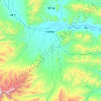
Name: Topografische Karte Gangga, Höhe, Relief.
Durchschnittliche Höhe: 4’981 m
Minimale Höhe: 4’299 m
Maximale Höhe: 7’301 m
Spenden
Rüste dich für dein nächstes Abenteuer:
Als Amazon-Partner verdient diese Seite an qualifizierten Käufen, ohne dass Ihnen zusätzliche Kosten entstehen.
Andere topografische Karten
Klicken Sie auf eine Karte, um ihre Topografie, ihre Höhe und ihr Relief anzuzeigen.
Mount Makalu
China > Tibet > Tingri County
Makalu (Nepali: मकालु हिमाल, romanized: Makālu himāl; Chinese: 马卡鲁峰; pinyin: Mǎkǎlǔ Fēng) is the fifth-highest mountain on Earth, with a summit at an elevation of 8,485 metres (27,838 ft) AMSL. It is located in the Mahalangur Himalayas 19 km (12 mi) southeast of Mount Everest,…
Durchschnittliche Höhe: 7’479 m
Spenden
Rüste dich für dein nächstes Abenteuer:
Als Amazon-Partner verdient diese Seite an qualifizierten Käufen, ohne dass Ihnen zusätzliche Kosten entstehen.
Cho Oyu
China > Tibet > Tingri County
Cho Oyu's height was originally measured at 26,750 feet (8,150 m) and at the time of the first ascent it was considered the 7th highest mountain on earth, after Dhaulagiri at 8,167 metres (26,795 ft) (Manaslu, now 8,156 metres (26,759 ft), was also estimated lower at 26,658 feet (8,125 m)). A 1984 estimate of…
Durchschnittliche Höhe: 7’339 m
Spenden
Rüste dich für dein nächstes Abenteuer:
Als Amazon-Partner verdient diese Seite an qualifizierten Käufen, ohne dass Ihnen zusätzliche Kosten entstehen.
Cho Oyu
China > Tibet > Tingri County
Cho Oyu's height was originally measured at 26,750 feet (8,150 m) and at the time of the first ascent it was considered the 7th highest mountain on earth, after Dhaulagiri at 8,167 metres (26,795 ft) (Manaslu, now 8,156 metres (26,759 ft), was also estimated lower at 26,658 feet (8,125 m)). A 1984 estimate of…
Durchschnittliche Höhe: 7’339 m
Mount Makalu
China > Tibet > Tingri County
Makalu (Nepali: मकालु हिमाल, romanized: Makālu himāl; Chinese: 马卡鲁峰; pinyin: Mǎkǎlǔ Fēng) is the fifth-highest mountain on Earth, with a summit at an elevation of 8,485 metres (27,838 ft) AMSL. It is located in the Mahalangur Himalayas 19 km (12 mi) southeast of Mount Everest,…
Durchschnittliche Höhe: 7’479 m