
Topografische Karte Ferndale
Interaktive Karte
Klicken Sie auf die Karte, um die Höhe anzuzeigen.
Über diese Karte
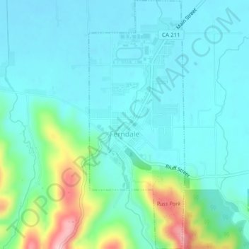
Name: Topografische Karte Ferndale, Höhe, Relief.
Ort: Ferndale, Humboldt County, California, United States (40.56280 -124.26948 40.59181 -124.25471)
Durchschnittliche Höhe: 39 m
Minimale Höhe: 0 m
Maximale Höhe: 194 m
Andere topografische Karten
Klicken Sie auf eine Karte, um ihre Topografie, ihre Höhe und ihr Relief anzuzeigen.
Lone Star Junction
United States > California > Humboldt County
Lone Star Junction, Humboldt County, California, United States
Durchschnittliche Höhe: 614 m
Eureka
United States > California > Humboldt County > Eureka
Eureka, Humboldt County, California, 95502, United States
Durchschnittliche Höhe: 100 m
Eureka
United States > California > Humboldt County
Eureka, Humboldt County, California, United States
Durchschnittliche Höhe: 19 m
Capetown
United States > California > Humboldt County
Capetown, Humboldt County, California, United States
Durchschnittliche Höhe: 163 m