
Topografische Karte Rapid City
Interaktive Karte
Klicken Sie auf die Karte, um die Höhe anzuzeigen.
Rapid City
Rapid City features a temperate semi-arid climate (Köppen: BSk) bordering on a hot-summer humid continental climate (Köppen: Dwa), and is part of USDA Hardiness zone 5b. Its location makes its climate unlike both the higher elevations of the Black Hills to the west and the Great Plains to the east. It is characterized by long arid summers and long dry winters, with short but distinct spring and autumn seasons. Precipitation averages 17.44 inches or 443.0 millimetres annually, but has historically ranged from 9.12 inches or 231.6 millimetres in 1974 to 27.70 inches or 703.6 millimetres in 1946.
Über diese Karte
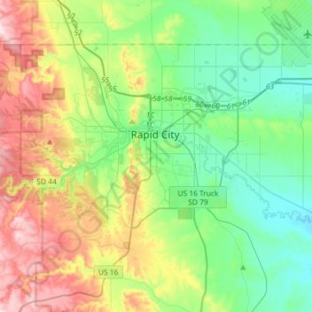
Name: Topografische Karte Rapid City, Höhe, Relief.
Ort: Rapid City, Pennington County, South Dakota, United States (43.99492 -103.32635 44.13679 -103.03791)
Durchschnittliche Höhe: 1’068 m
Minimale Höhe: 914 m
Maximale Höhe: 1’390 m
Andere topografische Karten
Klicken Sie auf eine Karte, um ihre Topografie, ihre Höhe und ihr Relief anzuzeigen.