
Spenden
Rüste dich für dein nächstes Abenteuer:
Als Amazon-Partner verdient diese Seite an qualifizierten Käufen, ohne dass Ihnen zusätzliche Kosten entstehen.
Topografische Karte Glasgow
Klicken Sie auf die Karte, um die Höhe anzuzeigen.
Spenden
Rüste dich für dein nächstes Abenteuer:
Als Amazon-Partner verdient diese Seite an qualifizierten Käufen, ohne dass Ihnen zusätzliche Kosten entstehen.
Glasgow
According to the United States Census Bureau, the city has a total area of 1.43 square miles (3.7 km2), all land. The town has an elevation of 2,093 feet (638 m). It is nestled in the Milk River Valley with the river itself meandering along to south.
Spenden
Rüste dich für dein nächstes Abenteuer:
Als Amazon-Partner verdient diese Seite an qualifizierten Käufen, ohne dass Ihnen zusätzliche Kosten entstehen.
Über diese Karte
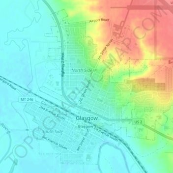
Name: Topografische Karte Glasgow, Höhe, Relief.
Ort: Glasgow, Valley County, Montana, United States (48.18836 -106.65042 48.21255 -106.61272)
Durchschnittliche Höhe: 654 m
Minimale Höhe: 633 m
Maximale Höhe: 700 m
Spenden
Rüste dich für dein nächstes Abenteuer:
Als Amazon-Partner verdient diese Seite an qualifizierten Käufen, ohne dass Ihnen zusätzliche Kosten entstehen.
Andere topografische Karten
Klicken Sie auf eine Karte, um ihre Topografie, ihre Höhe und ihr Relief anzuzeigen.