
Topografische Karte Zamarramala
Klicken Sie auf die Karte, um die Höhe anzuzeigen.
Über diese Karte
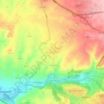
Name: Topografische Karte Zamarramala, Höhe, Relief.
Ort: Zamarramala, Segovia, Castilla y León, 40003, España (40.94541 -4.15458 40.98541 -4.11458)
Durchschnittliche Höhe: 995 m
Minimale Höhe: 898 m
Maximale Höhe: 1’077 m
Andere topografische Karten
Klicken Sie auf eine Karte, um ihre Topografie, ihre Höhe und ihr Relief anzuzeigen.