Topografische Karte Mounds View
Interaktive Karte
Klicken Sie auf die Karte, um die Höhe anzuzeigen.
Über diese Karte
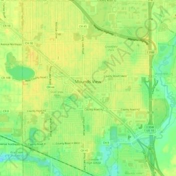
Name: Topografische Karte Mounds View, Höhe, Relief.
Ort: Mounds View, Ramsey County, Minnesota, United States (45.08631 -93.22784 45.12455 -93.18732)
Durchschnittliche Höhe: 276 m
Minimale Höhe: 261 m
Maximale Höhe: 284 m
Andere topografische Karten
Klicken Sie auf eine Karte, um ihre Topografie, ihre Höhe und ihr Relief anzuzeigen.
Saint Paul
United States > Minnesota > Ramsey County
Saint Paul, Ramsey County, Minnesota, United States
Durchschnittliche Höhe: 268 m
North St. Paul
United States > Minnesota > Ramsey County
North St. Paul, Ramsey County, Minnesota, United States
Durchschnittliche Höhe: 302 m
Beaver Lake
United States > Minnesota > Ramsey County > Maplewood
Beaver Lake, Maplewood, Ramsey County, Minnesota, United States
Durchschnittliche Höhe: 304 m
Little Canada
United States > Minnesota > Ramsey County
Little Canada, Ramsey County, Minnesota, United States
Durchschnittliche Höhe: 277 m
Saint Paul
United States > Minnesota > Ramsey County > Saint Paul
Saint Paul, Ramsey County, Minnesota, 55101, United States
Durchschnittliche Höhe: 273 m
North Oaks
United States > Minnesota > Ramsey County
North Oaks, Ramsey County, Minnesota, United States
Durchschnittliche Höhe: 280 m
Roseville
United States > Minnesota > Ramsey County
Roseville, Ramsey County, Minnesota, 55113, United States
Durchschnittliche Höhe: 284 m
White Bear Township
United States > Minnesota > Ramsey County
White Bear Township, Ramsey County, Minnesota, 55110, United States
Durchschnittliche Höhe: 282 m
Southeast
United States > Minnesota > Ramsey County > Saint Paul
Southeast, Saint Paul, Ramsey County, Minnesota, United States
Durchschnittliche Höhe: 263 m
Highland Park
United States > Minnesota > Ramsey County > Saint Paul
Highland Park, Highland, Saint Paul, Ramsey County, Minnesota, United States
Durchschnittliche Höhe: 255 m
White Bear Lake
United States > Minnesota > Ramsey County
White Bear Lake, Ramsey County, Minnesota, 55110, United States
Durchschnittliche Höhe: 289 m
Summit Hill
United States > Minnesota > Ramsey County > Saint Paul
Summit Hill, Saint Paul, Ramsey County, Minnesota, United States
Durchschnittliche Höhe: 267 m
Maplewood
United States > Minnesota > Ramsey County
Maplewood, Ramsey County, Minnesota, United States
Durchschnittliche Höhe: 279 m
New Brighton
United States > Minnesota > Ramsey County
New Brighton, Ramsey County, Minnesota, 55112, United States
Durchschnittliche Höhe: 282 m
South Saint Anthony Park
United States > Minnesota > Ramsey County > Saint Paul
South Saint Anthony Park, Saint Anthony Park, Saint Paul, Ramsey County, Minnesota, United States
Durchschnittliche Höhe: 270 m
Vadnais Heights
United States > Minnesota > Ramsey County
Vadnais Heights, Ramsey County, Minnesota, 55127, United States
Durchschnittliche Höhe: 279 m
White Bear Township
United States > Minnesota > Ramsey County
White Bear Township, Ramsey County, Minnesota, United States
Durchschnittliche Höhe: 283 m
Shoreview
United States > Minnesota > Ramsey County
Shoreview, Ramsey County, Minnesota, 55126, United States
Durchschnittliche Höhe: 279 m