
Topografische Karte Podgórze
Interaktive Karte
Klicken Sie auf die Karte, um die Höhe anzuzeigen.
Über diese Karte
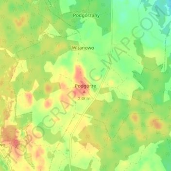
Name: Topografische Karte Podgórze, Höhe, Relief.
Durchschnittliche Höhe: 204 m
Minimale Höhe: 174 m
Maximale Höhe: 235 m
Andere topografische Karten
Klicken Sie auf eine Karte, um ihre Topografie, ihre Höhe und ihr Relief anzuzeigen.
Półczno
Poland > Pomeranian Voivodeship > Bytów County
Półczno, gmina Studzienice, Bytów County, Pomeranian Voivodeship, 77-125, Poland
Durchschnittliche Höhe: 193 m
Będzieszyn
Poland > Pomeranian Voivodeship > Bytów County > Jasień
Będzieszyn, Jasień, gmina Czarna Dąbrówka, Bytów County, Pomeranian Voivodeship, Poland
Durchschnittliche Höhe: 154 m
Pomysk Wielki
Poland > Pomeranian Voivodeship > Bytów County > Pomysk Wielki
Pomysk Wielki, gmina Bytów, Bytów County, Pomeranian Voivodeship, 77-100, Poland
Durchschnittliche Höhe: 170 m