
Topografische Karte Long Lake
Interaktive Karte
Klicken Sie auf die Karte, um die Höhe anzuzeigen.
Über diese Karte
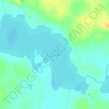
Name: Topografische Karte Long Lake, Höhe, Relief.
Ort: Long Lake, Beltrami County, Minnesota, United States (47.64219 -94.99671 47.66230 -94.95794)
Durchschnittliche Höhe: 420 m
Minimale Höhe: 411 m
Maximale Höhe: 444 m
Andere topografische Karten
Klicken Sie auf eine Karte, um ihre Topografie, ihre Höhe und ihr Relief anzuzeigen.
Green Lake
United States > Minnesota > Beltrami County > Little Rock
Green Lake, Little Rock, Beltrami County, Minnesota, United States
Durchschnittliche Höhe: 379 m
Bemidji
United States > Minnesota > Beltrami County
Bemidji, Beltrami County, Minnesota, 56601, United States
Durchschnittliche Höhe: 417 m
Movil Lake Dam
United States > Minnesota > Beltrami County
Movil Lake Dam, Beltrami County, Minnesota, United States
Durchschnittliche Höhe: 416 m
Ponemah
United States > Minnesota > Beltrami County
Ponemah, Beltrami County, Minnesota, 56666, United States
Durchschnittliche Höhe: 362 m
Waskish
United States > Minnesota > Beltrami County
Waskish, Beltrami County, Minnesota, 56685, United States
Durchschnittliche Höhe: 359 m
Little Rock
United States > Minnesota > Beltrami County
Little Rock, Beltrami County, Minnesota, United States
Durchschnittliche Höhe: 375 m
Solway
United States > Minnesota > Beltrami County > Solway
Solway, Beltrami County, Minnesota, United States
Durchschnittliche Höhe: 440 m
Bemidji
United States > Minnesota > Beltrami County > Bemidji
Bemidji, Beltrami County, Minnesota, 56601, United States
Durchschnittliche Höhe: 416 m
Lake Bemidji
United States > Minnesota > Beltrami County > Bemidji
Lake Bemidji, Bemidji, Beltrami County, Minnesota, 56601, United States
Durchschnittliche Höhe: 415 m
Wilton
United States > Minnesota > Beltrami County
Wilton, Beltrami County, Minnesota, 56687, United States
Durchschnittliche Höhe: 425 m