
Spenden
Rüste dich für dein nächstes Abenteuer:
Als Amazon-Partner verdient diese Seite an qualifizierten Käufen, ohne dass Ihnen zusätzliche Kosten entstehen.
Topografische Karte Gorges State Park
Klicken Sie auf die Karte, um die Höhe anzuzeigen.
Spenden
Rüste dich für dein nächstes Abenteuer:
Als Amazon-Partner verdient diese Seite an qualifizierten Käufen, ohne dass Ihnen zusätzliche Kosten entstehen.
Gorges State Park
Following the flood, local citizens eventually sold large land tracts in the Gorges to Singer Sewing Machine Company, which logged most of the land. Then, in the 1940s and 1950s, Singer sold the land to Duke Energy Corporation. The corporation purchased the land for its steep topography and high rainfall, which offered opportunities for development of hydropower projects.
Spenden
Rüste dich für dein nächstes Abenteuer:
Als Amazon-Partner verdient diese Seite an qualifizierten Käufen, ohne dass Ihnen zusätzliche Kosten entstehen.
Über diese Karte
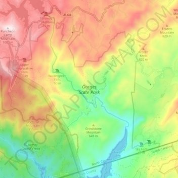
Name: Topografische Karte Gorges State Park, Höhe, Relief.
Durchschnittliche Höhe: 682 m
Minimale Höhe: 329 m
Maximale Höhe: 1’081 m
Spenden
Rüste dich für dein nächstes Abenteuer:
Als Amazon-Partner verdient diese Seite an qualifizierten Käufen, ohne dass Ihnen zusätzliche Kosten entstehen.
Andere topografische Karten
Klicken Sie auf eine Karte, um ihre Topografie, ihre Höhe und ihr Relief anzuzeigen.
Spenden
Rüste dich für dein nächstes Abenteuer:
Als Amazon-Partner verdient diese Seite an qualifizierten Käufen, ohne dass Ihnen zusätzliche Kosten entstehen.
Spenden
Rüste dich für dein nächstes Abenteuer:
Als Amazon-Partner verdient diese Seite an qualifizierten Käufen, ohne dass Ihnen zusätzliche Kosten entstehen.
Spenden
Rüste dich für dein nächstes Abenteuer:
Als Amazon-Partner verdient diese Seite an qualifizierten Käufen, ohne dass Ihnen zusätzliche Kosten entstehen.
Forest Hills
United States > North Carolina > Transylvania County > Brevard
Durchschnittliche Höhe: 670 m
Spenden
Rüste dich für dein nächstes Abenteuer:
Als Amazon-Partner verdient diese Seite an qualifizierten Käufen, ohne dass Ihnen zusätzliche Kosten entstehen.
Little Bald Mountain
United States > North Carolina > Transylvania County
Durchschnittliche Höhe: 1’377 m
Sugar Loaf Mountain
United States > North Carolina > Transylvania County
Durchschnittliche Höhe: 660 m
Spenden
Rüste dich für dein nächstes Abenteuer:
Als Amazon-Partner verdient diese Seite an qualifizierten Käufen, ohne dass Ihnen zusätzliche Kosten entstehen.
Slick Rock Mountain
United States > North Carolina > Transylvania County
Durchschnittliche Höhe: 964 m
Spenden
Rüste dich für dein nächstes Abenteuer:
Als Amazon-Partner verdient diese Seite an qualifizierten Käufen, ohne dass Ihnen zusätzliche Kosten entstehen.