
Topografische Karte San Miguel de Laciana
Interaktive Karte
Klicken Sie auf die Karte, um die Höhe anzuzeigen.
Über diese Karte
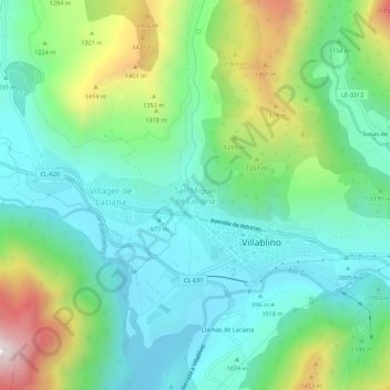
Name: Topografische Karte San Miguel de Laciana, Höhe, Relief.
Durchschnittliche Höhe: 1’163 m
Minimale Höhe: 940 m
Maximale Höhe: 1’723 m
Andere topografische Karten
Klicken Sie auf eine Karte, um ihre Topografie, ihre Höhe und ihr Relief anzuzeigen.
Lumajo
España > Castilla y León > Villablino
Lumajo, Villablino, León, Castilla y León, España
Durchschnittliche Höhe: 1’529 m
Robles de Laciana
España > Castilla y León > Villablino > Robles de Laciana
Robles de Laciana, Villablino, León, Castilla y León, 24139, España
Durchschnittliche Höhe: 1’248 m
Campas de Genestoso
España > Castilla y León > Villablino
Campas de Genestoso, Villablino, Montaña de Luna, León, Castilla y León, España
Durchschnittliche Höhe: 1’689 m