
Spenden
Rüste dich für dein nächstes Abenteuer:
Als Amazon-Partner verdient diese Seite an qualifizierten Käufen, ohne dass Ihnen zusätzliche Kosten entstehen.
Topografische Karte Peasedown St. John
Klicken Sie auf die Karte, um die Höhe anzuzeigen.
Spenden
Rüste dich für dein nächstes Abenteuer:
Als Amazon-Partner verdient diese Seite an qualifizierten Käufen, ohne dass Ihnen zusätzliche Kosten entstehen.
Über diese Karte
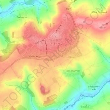
Name: Topografische Karte Peasedown St. John, Höhe, Relief.
Durchschnittliche Höhe: 125 m
Minimale Höhe: 60 m
Maximale Höhe: 172 m
Spenden
Rüste dich für dein nächstes Abenteuer:
Als Amazon-Partner verdient diese Seite an qualifizierten Käufen, ohne dass Ihnen zusätzliche Kosten entstehen.
Andere topografische Karten
Klicken Sie auf eine Karte, um ihre Topografie, ihre Höhe und ihr Relief anzuzeigen.
Keynsham Memorial Park
United Kingdom > England > Bath and North East Somerset > Keynsham
Durchschnittliche Höhe: 29 m
Hallatrow
United Kingdom > England > Bath and North East Somerset > High Littleton
Durchschnittliche Höhe: 119 m
Old Mills
United Kingdom > England > Bath and North East Somerset > Paulton
Durchschnittliche Höhe: 126 m
Norton Hawkfield
United Kingdom > England > Bath and North East Somerset > Norton Malreward
Durchschnittliche Höhe: 96 m
Spenden
Rüste dich für dein nächstes Abenteuer:
Als Amazon-Partner verdient diese Seite an qualifizierten Käufen, ohne dass Ihnen zusätzliche Kosten entstehen.
Amesbury
United Kingdom > England > Bath and North East Somerset > Timsbury
Durchschnittliche Höhe: 130 m
Knowle Hill
United Kingdom > England > Bath and North East Somerset > Chew Magna
Durchschnittliche Höhe: 65 m
Little Solsbury Hill
United Kingdom > England > Bath and North East Somerset > Batheaston
Durchschnittliche Höhe: 88 m
Bathwick Hill
United Kingdom > England > Bath and North East Somerset > Bath
Number 1 (Bathwick Lodge) is a 2-storey villa with a steep Mansard room, built in 1825, extended in 1840 and the late C19. Probably by John Pinch the Elder.[4] Number 2 is from the early 19th century and has shutters over the windows.[11] Number 3 includes a porch which is elaborately enriched with carving,…
Durchschnittliche Höhe: 93 m
Spenden
Rüste dich für dein nächstes Abenteuer:
Als Amazon-Partner verdient diese Seite an qualifizierten Käufen, ohne dass Ihnen zusätzliche Kosten entstehen.
North Wick
United Kingdom > England > Bath and North East Somerset > Chew Magna
Durchschnittliche Höhe: 110 m
Carlingcott
United Kingdom > England > Bath and North East Somerset > Peasedown St. John
Durchschnittliche Höhe: 123 m
Tadwick
United Kingdom > England > Bath and North East Somerset > Swainswick
Durchschnittliche Höhe: 161 m
Spenden
Rüste dich für dein nächstes Abenteuer:
Als Amazon-Partner verdient diese Seite an qualifizierten Käufen, ohne dass Ihnen zusätzliche Kosten entstehen.
Pipehouse
United Kingdom > England > Bath and North East Somerset > Hinton Charterhouse
Durchschnittliche Höhe: 94 m
Sydney Gardens
United Kingdom > England > Bath and North East Somerset > Bath
Durchschnittliche Höhe: 75 m
Stoney Littleton
United Kingdom > England > Bath and North East Somerset > Shoscombe
Durchschnittliche Höhe: 116 m
Spenden
Rüste dich für dein nächstes Abenteuer:
Als Amazon-Partner verdient diese Seite an qualifizierten Käufen, ohne dass Ihnen zusätzliche Kosten entstehen.
Clutton Hill
United Kingdom > England > Bath and North East Somerset > Farmborough
Durchschnittliche Höhe: 133 m
Spenden
Rüste dich für dein nächstes Abenteuer:
Als Amazon-Partner verdient diese Seite an qualifizierten Käufen, ohne dass Ihnen zusätzliche Kosten entstehen.
Cholwell
United Kingdom > England > Bath and North East Somerset > Clutton
Durchschnittliche Höhe: 130 m
Sharpstone
United Kingdom > England > Bath and North East Somerset > Freshford
Durchschnittliche Höhe: 93 m
Park Corner
United Kingdom > England > Bath and North East Somerset > Freshford > Park Corner
Durchschnittliche Höhe: 93 m
Spenden
Rüste dich für dein nächstes Abenteuer:
Als Amazon-Partner verdient diese Seite an qualifizierten Käufen, ohne dass Ihnen zusätzliche Kosten entstehen.
Maes Knoll
United Kingdom > England > Bath and North East Somerset > Norton Malreward
Durchschnittliche Höhe: 110 m
Sydney Gardens
United Kingdom > England > Bath and North East Somerset > Bath
Durchschnittliche Höhe: 77 m
Wick Green
United Kingdom > England > Bath and North East Somerset > Bishop Sutton
Durchschnittliche Höhe: 82 m
Whitley Batts
United Kingdom > England > Bath and North East Somerset > Pensford
Durchschnittliche Höhe: 87 m
Spenden
Rüste dich für dein nächstes Abenteuer:
Als Amazon-Partner verdient diese Seite an qualifizierten Käufen, ohne dass Ihnen zusätzliche Kosten entstehen.
Chewton Keynsham
United Kingdom > England > Bath and North East Somerset > Compton Dando
Durchschnittliche Höhe: 57 m
Mearns
United Kingdom > England > Bath and North East Somerset > Farmborough
Durchschnittliche Höhe: 129 m
Clandown
United Kingdom > England > Bath and North East Somerset > Radstock
Durchschnittliche Höhe: 118 m
Spenden
Rüste dich für dein nächstes Abenteuer:
Als Amazon-Partner verdient diese Seite an qualifizierten Käufen, ohne dass Ihnen zusätzliche Kosten entstehen.