Geolokalisieren

Topografische Karte Palatka

Klicken Sie auf die Karte, um die Höhe anzuzeigen.

Palatka

Palatka is located at 29°38′N 81°39′W / 29.633°N 81.650°W / 29.633; -81.650. The total area is 7.5 square miles (19 km2) and has an average elevation of 16 feet (4.8 m) above sea level. The city is located in the southern portion of the Lower St. Johns River basin.

Wikipedia (CC-BY-SA 3.0)

Über diese Karte

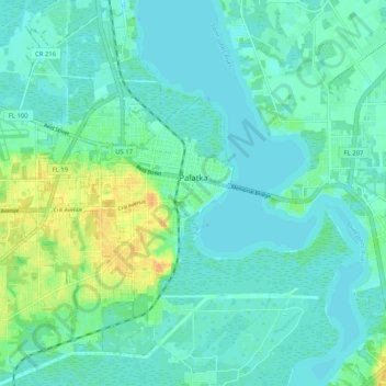
Name: Topografische Karte Palatka, Höhe, Relief.

Ort: Palatka, Putnam County, Florida, United States (29.60771 -81.72944 29.68270 -81.62647)

Durchschnittliche Höhe: 8 m

Minimale Höhe: 0 m

Maximale Höhe: 31 m

Andere topografische Karten

Klicken Sie auf eine Karte, um ihre Topografie, ihre Höhe und ihr Relief anzuzeigen.

Putnam Hall

United States > Florida > Putnam County

Durchschnittliche Höhe: 34 m

Melrose

United States > Florida > Putnam County

Durchschnittliche Höhe: 45 m

East Palatka

United States > Florida > Putnam County

Durchschnittliche Höhe: 6 m

Georgetown

United States > Florida > Putnam County

Georgetown is located at 29°23′29″N 81°38′19″W / 29.391362°N 81.638689°W / 29.391362; -81.638689 (29.391362, -81.638689). Its elevation in 23 feet (7 m).

Durchschnittliche Höhe: 6 m

Mariner Lake

United States > Florida > Putnam County

Durchschnittliche Höhe: 37 m

Bardin

United States > Florida > Putnam County

Durchschnittliche Höhe: 7 m

Melrose

United States > Florida > Putnam County

Durchschnittliche Höhe: 45 m

San Mateo

United States > Florida > Putnam County

San Mateo is located at 29°36′25″N 81°35′06″W / 29.607°N 81.585°W / 29.607; -81.585, with an elevation of 72 feet (22 m).

Durchschnittliche Höhe: 10 m

East Palatka

United States > Florida > Putnam County

Durchschnittliche Höhe: 5 m

Bostwick

United States > Florida > Putnam County

Durchschnittliche Höhe: 12 m

Dunns Creek

United States > Florida > Putnam County

Durchschnittliche Höhe: 7 m

Satsuma

United States > Florida > Putnam County

Durchschnittliche Höhe: 19 m

Dunns Creek

United States > Florida > Putnam County

Durchschnittliche Höhe: 7 m

Georgetown

United States > Florida > Putnam County

Georgetown is located at 29°23′29″N 81°38′19″W / 29.391362°N 81.638689°W / 29.391362; -81.638689 (29.391362, -81.638689). Its elevation in 23 feet (7 m).

Durchschnittliche Höhe: 6 m

Crossley

United States > Florida > Putnam County > Crossley

Durchschnittliche Höhe: 30 m

Rüste dich für dein nächstes Abenteuer:

🥛Zusammenlegbare Schalen & Flaschen - Platzsparende Lösungen für unterwegs
🧤Seiden-Unterziehhandschuhe - Zusätzliche Wärme bei minimalem Volumen
🧼Biologische Outdoor-Seife - Umweltfreundliche Hygiene in der Natur
🔦LED-Taschenlampen - Zuverlässige Lichtquelle für Notfälle und Camping
🔦Campinglaternen - Rundum-Beleuchtung für das Zelt

Als Amazon-Partner verdient diese Seite an qualifizierten Käufen, ohne dass Ihnen zusätzliche Kosten entstehen.