
Spenden
Rüste dich für dein nächstes Abenteuer:
Als Amazon-Partner verdient diese Seite an qualifizierten Käufen, ohne dass Ihnen zusätzliche Kosten entstehen.
Topografische Karte Cherry Log
Klicken Sie auf die Karte, um die Höhe anzuzeigen.
Spenden
Rüste dich für dein nächstes Abenteuer:
Als Amazon-Partner verdient diese Seite an qualifizierten Käufen, ohne dass Ihnen zusätzliche Kosten entstehen.
Über diese Karte
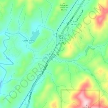
Name: Topografische Karte Cherry Log, Höhe, Relief.
Ort: Cherry Log, Gilmer County, Georgia, 30522, United States (34.76036 -84.41076 34.80036 -84.37076)
Durchschnittliche Höhe: 522 m
Minimale Höhe: 422 m
Maximale Höhe: 728 m
Spenden
Rüste dich für dein nächstes Abenteuer:
Als Amazon-Partner verdient diese Seite an qualifizierten Käufen, ohne dass Ihnen zusätzliche Kosten entstehen.
Andere topografische Karten
Klicken Sie auf eine Karte, um ihre Topografie, ihre Höhe und ihr Relief anzuzeigen.
Ellijay
United States > Georgia > Gilmer County
Ellijay sits within a rugged and mountainous terrain, characterized by rolling hills, deep valleys, and ridgelines that are part of the larger Appalachian Mountain system. The area has an average elevation of about 1,390 feet, though nearby peaks like Walnut Mountain rise to elevations over 2,500 feet. The…
Durchschnittliche Höhe: 424 m
Spenden
Rüste dich für dein nächstes Abenteuer:
Als Amazon-Partner verdient diese Seite an qualifizierten Käufen, ohne dass Ihnen zusätzliche Kosten entstehen.
Ellijay
United States > Georgia > Gilmer County
Ellijay lies within the Humid subtropical climate zone along with the majority of the rest of the Southeastern United States. The highest elevations in the surrounding region reside in the oceanic climate. Ellijay enjoys cool winters and warm summers, but neither would be considered extreme due to its slightly…
Durchschnittliche Höhe: 424 m
Ellijay
United States > Georgia > Gilmer County
Ellijay lies within the Humid subtropical climate zone along with the majority of the rest of the southeastern United States. The highest elevations in the surrounding region reside in the Subtropical highland climate. Ellijay enjoys cool winters and warm summers, but neither would be considered extreme thanks…
Durchschnittliche Höhe: 424 m