
Spenden
Rüste dich für dein nächstes Abenteuer:
Als Amazon-Partner verdient diese Seite an qualifizierten Käufen, ohne dass Ihnen zusätzliche Kosten entstehen.
Topografische Karte Rock
Klicken Sie auf die Karte, um die Höhe anzuzeigen.
Spenden
Rüste dich für dein nächstes Abenteuer:
Als Amazon-Partner verdient diese Seite an qualifizierten Käufen, ohne dass Ihnen zusätzliche Kosten entstehen.
Über diese Karte
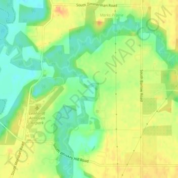
Name: Topografische Karte Rock, Höhe, Relief.
Ort: Rock, Clackamas County, Oregon, 97032, United States (45.18252 -122.73596 45.18594 -122.73192)
Durchschnittliche Höhe: 45 m
Minimale Höhe: 26 m
Maximale Höhe: 62 m
Spenden
Rüste dich für dein nächstes Abenteuer:
Als Amazon-Partner verdient diese Seite an qualifizierten Käufen, ohne dass Ihnen zusätzliche Kosten entstehen.
Andere topografische Karten
Klicken Sie auf eine Karte, um ihre Topografie, ihre Höhe und ihr Relief anzuzeigen.
Spenden
Rüste dich für dein nächstes Abenteuer:
Als Amazon-Partner verdient diese Seite an qualifizierten Käufen, ohne dass Ihnen zusätzliche Kosten entstehen.
Spenden
Rüste dich für dein nächstes Abenteuer:
Als Amazon-Partner verdient diese Seite an qualifizierten Käufen, ohne dass Ihnen zusätzliche Kosten entstehen.
Spenden
Rüste dich für dein nächstes Abenteuer:
Als Amazon-Partner verdient diese Seite an qualifizierten Käufen, ohne dass Ihnen zusätzliche Kosten entstehen.
Boring
United States > Oregon > Clackamas County
Boring's landscape is hilly, with its elevation ranging between 548 feet (167 m) and 755 feet (230 m). Several creeks run west through the community limits into the Clackamas River, including Doane Creek, North Fork Deep Creek, and Tickle Creek.
Durchschnittliche Höhe: 182 m
Sandy
United States > Oregon > Clackamas County
According to the United States Census Bureau, the city has a total area of 3.14 square miles (8.13 km2), consisting almost entirely of land. Its elevation is 967 feet (295 m).
Durchschnittliche Höhe: 247 m
Spenden
Rüste dich für dein nächstes Abenteuer:
Als Amazon-Partner verdient diese Seite an qualifizierten Käufen, ohne dass Ihnen zusätzliche Kosten entstehen.
Spenden
Rüste dich für dein nächstes Abenteuer:
Als Amazon-Partner verdient diese Seite an qualifizierten Käufen, ohne dass Ihnen zusätzliche Kosten entstehen.
Bagby Hot Springs
United States > Oregon > Clackamas County
Bagby Hot Springs are natural hot springs in the Mount Hood National Forest, about 67 miles (108 km) southeast of Portland, Oregon, United States and about 98 miles (158 km) east of Salem, Oregon. The springs are in the Cascade Mountains in a heavily forested area at elevation 2280 ft (695 m). They are just…
Durchschnittliche Höhe: 880 m
Mount Talbert
United States > Oregon > Clackamas County > Happy Valley
Mount Talbert is a volcanic cinder cone in Clackamas County, Oregon. It is part of the Boring Lava Field, a zone of ancient volcanic activity in the area around Portland. Its summit rises to an elevation of 740+ ft (230+ m).
Durchschnittliche Höhe: 96 m
Spenden
Rüste dich für dein nächstes Abenteuer:
Als Amazon-Partner verdient diese Seite an qualifizierten Käufen, ohne dass Ihnen zusätzliche Kosten entstehen.
The Villages at Mount Hood
United States > Oregon > Clackamas County > Welches
Durchschnittliche Höhe: 808 m
Sandy
United States > Oregon > Clackamas County
According to the United States Census Bureau, the city has a total area of 3.14 square miles (8.13 km2), consisting almost entirely of land. Its elevation is 967 feet (295 m).
Durchschnittliche Höhe: 247 m
Spenden
Rüste dich für dein nächstes Abenteuer:
Als Amazon-Partner verdient diese Seite an qualifizierten Käufen, ohne dass Ihnen zusätzliche Kosten entstehen.
Wilsonville
United States > Oregon > Clackamas County
Wilsonville is located on the southern edge of the Portland metropolitan area sitting at an elevation of 154 feet (47 m) above sea level. Primarily in the southwestern part of Clackamas County, the northern section is in Washington County. It is located on the north side of the Willamette River around where…
Durchschnittliche Höhe: 60 m
Sandy
United States > Oregon > Clackamas County
According to the United States Census Bureau, the city has a total area of 3.14 square miles (8.13 km2), consisting almost entirely of land. Its elevation is 967 feet (295 m).
Durchschnittliche Höhe: 247 m
Spenden
Rüste dich für dein nächstes Abenteuer:
Als Amazon-Partner verdient diese Seite an qualifizierten Käufen, ohne dass Ihnen zusätzliche Kosten entstehen.
Oswego Lake
United States > Oregon > Clackamas County > Lake Oswego > Jean
Durchschnittliche Höhe: 92 m
Spenden
Rüste dich für dein nächstes Abenteuer:
Als Amazon-Partner verdient diese Seite an qualifizierten Käufen, ohne dass Ihnen zusätzliche Kosten entstehen.
Spenden
Rüste dich für dein nächstes Abenteuer:
Als Amazon-Partner verdient diese Seite an qualifizierten Käufen, ohne dass Ihnen zusätzliche Kosten entstehen.
Mount Talbert
United States > Oregon > Clackamas County > Happy Valley
Mount Talbert is a volcanic cinder cone in Clackamas County, Oregon. It is part of the Boring Lava Field, a zone of ancient volcanic activity in the area around Portland. Its summit rises to an elevation of 740+ ft (230+ m).
Durchschnittliche Höhe: 96 m
Spenden
Rüste dich für dein nächstes Abenteuer:
Als Amazon-Partner verdient diese Seite an qualifizierten Käufen, ohne dass Ihnen zusätzliche Kosten entstehen.
Spenden
Rüste dich für dein nächstes Abenteuer:
Als Amazon-Partner verdient diese Seite an qualifizierten Käufen, ohne dass Ihnen zusätzliche Kosten entstehen.
Spenden
Rüste dich für dein nächstes Abenteuer:
Als Amazon-Partner verdient diese Seite an qualifizierten Käufen, ohne dass Ihnen zusätzliche Kosten entstehen.
Spenden
Rüste dich für dein nächstes Abenteuer:
Als Amazon-Partner verdient diese Seite an qualifizierten Käufen, ohne dass Ihnen zusätzliche Kosten entstehen.