
Topografische Karte Zeeland
Interaktive Karte
Klicken Sie auf die Karte, um die Höhe anzuzeigen.
Über diese Karte
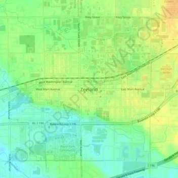
Name: Topografische Karte Zeeland, Höhe, Relief.
Ort: Zeeland, Ottawa County, Michigan, 49464, United States (42.79792 -86.03849 42.82690 -85.98965)
Durchschnittliche Höhe: 195 m
Minimale Höhe: 180 m
Maximale Höhe: 210 m
According to the United States Census Bureau, the city has a total area of 3.01 square miles (7.80 km2), of which 2.99 square miles (7.74 km2) is land and 0.02 square miles (0.05 km2) is water. The town itself is located on a hill, giving the city a higher elevation compared to the surrounding township land. Much of the outlying areas contain farmland and forest.
Andere topografische Karten
Klicken Sie auf eine Karte, um ihre Topografie, ihre Höhe und ihr Relief anzuzeigen.
Holland
United States > Michigan > Ottawa County
Holland, Ottawa County, Michigan, 49423, United States
Durchschnittliche Höhe: 199 m
Helder Park
United States > Michigan > Ottawa County > Noordeloos
Helder Park, Noordeloos, Holland Charter Township, Ottawa County, Michigan, United States
Durchschnittliche Höhe: 198 m
Elgin
United States > Michigan > Ottawa County
Elgin, Tallmadge Charter Township, Ottawa County, Michigan, United States
Durchschnittliche Höhe: 194 m
Grand Haven
United States > Michigan > Ottawa County
Grand Haven, Ottawa County, Michigan, United States
Durchschnittliche Höhe: 182 m
Spring Lake
United States > Michigan > Ottawa County
Spring Lake, Spring Lake Township, Ottawa County, Michigan, United States
Durchschnittliche Höhe: 179 m
Spring Lake Township
United States > Michigan > Ottawa County
Spring Lake Township, Ottawa County, Michigan, United States
Durchschnittliche Höhe: 185 m
Allendale Charter Township
United States > Michigan > Ottawa County
Allendale Charter Township, Ottawa County, Michigan, 49401, United States
Durchschnittliche Höhe: 195 m
Georgetown Charter Township
United States > Michigan > Ottawa County
Georgetown Charter Township, Ottawa County, Michigan, 49428, United States
Durchschnittliche Höhe: 199 m
Park Township
United States > Michigan > Ottawa County
Park Township, Ottawa County, Michigan, United States
Durchschnittliche Höhe: 184 m
Hudsonville
United States > Michigan > Ottawa County
Hudsonville, Ottawa County, Michigan, 49426, United States
Durchschnittliche Höhe: 200 m
Borculo
United States > Michigan > Ottawa County
Borculo, Olive Township, Ottawa County, Michigan, United States
Durchschnittliche Höhe: 197 m
Grand Haven Charter Township
United States > Michigan > Ottawa County
Grand Haven Charter Township, Ottawa County, Michigan, 49417, United States
Durchschnittliche Höhe: 185 m
Ferrysburg
United States > Michigan > Ottawa County
Ferrysburg, Ottawa County, Michigan, United States
Durchschnittliche Höhe: 184 m
Robinson Township
United States > Michigan > Ottawa County
Robinson Township, Ottawa County, Michigan, United States
Durchschnittliche Höhe: 188 m
Chester Township
United States > Michigan > Ottawa County
Chester Township, Ottawa County, Michigan, 49403, United States
Durchschnittliche Höhe: 233 m
Holland Charter Township
United States > Michigan > Ottawa County
Holland Charter Township, Ottawa County, Michigan, 49424, United States
Durchschnittliche Höhe: 191 m
Zeeland Charter Township
United States > Michigan > Ottawa County
Zeeland Charter Township, Ottawa County, Michigan, United States
Durchschnittliche Höhe: 205 m
Nunica
United States > Michigan > Ottawa County
Nunica, Crockery Township, Ottawa County, Michigan, 49448, United States
Durchschnittliche Höhe: 190 m
Macatawa
United States > Michigan > Ottawa County
Macatawa, Park Township, Ottawa County, Michigan, 49434, United States
Durchschnittliche Höhe: 181 m