
Topografische Karte Old Beach
Interaktive Karte
Klicken Sie auf die Karte, um die Höhe anzuzeigen.
Über diese Karte
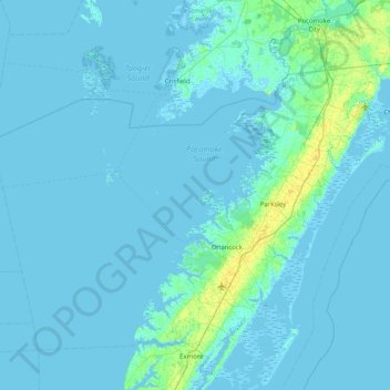
Name: Topografische Karte Old Beach, Höhe, Relief.
Ort: Old Beach, Accomack County, Virginia, United States (37.47541 -76.13410 38.11541 -75.49410)
Durchschnittliche Höhe: 2 m
Minimale Höhe: -4 m
Maximale Höhe: 23 m
Andere topografische Karten
Klicken Sie auf eine Karte, um ihre Topografie, ihre Höhe und ihr Relief anzuzeigen.
Hacksneck
United States > Virginia > Accomack County
Hacksneck, Accomack County, Virginia, 23358, United States
Durchschnittliche Höhe: 1 m
Cheeseman Island
United States > Virginia > Accomack County
Cheeseman Island, Accomack County, Virginia, 21866, United States
Durchschnittliche Höhe: 2 m
Painter
United States > Virginia > Accomack County
Painter, Accomack County, Virginia, United States
Durchschnittliche Höhe: 10 m
Tangier Island
United States > Virginia > Accomack County > Tangier
Tangier Island, Tangier, Accomack County, Virginia, 23440, United States
Durchschnittliche Höhe: 2 m
Deep Creek
United States > Virginia > Accomack County
Deep Creek, Accomack County, Virginia, United States
Durchschnittliche Höhe: 1 m
Wishart
United States > Virginia > Accomack County > Wishart
Wishart, Accomack County, Virginia, 23303, United States
Durchschnittliche Höhe: 5 m
Herring Island
United States > Virginia > Accomack County
Herring Island, Accomack County, Virginia, United States
Durchschnittliche Höhe: 2 m