

Topografische Karte Odenton
Klicken Sie auf die Karte, um die Höhe anzuzeigen.
Über diese Karte
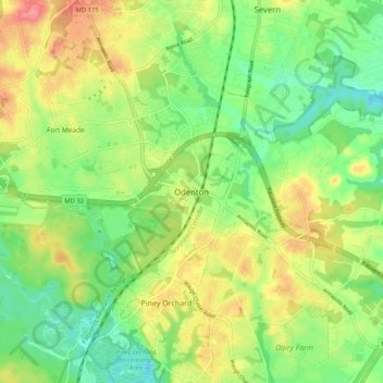
Name: Topografische Karte Odenton, Höhe, Relief.
Ort: Odenton, Anne Arundel County, Maryland, 21112, United States (39.04972 -76.74735 39.12972 -76.66735)
Durchschnittliche Höhe: 49 m
Minimale Höhe: 14 m
Maximale Höhe: 95 m
Andere topografische Karten
Klicken Sie auf eine Karte, um ihre Topografie, ihre Höhe und ihr Relief anzuzeigen.
Franklin Point State Park
United States > Maryland > Anne Arundel County > Columbia Beach
Durchschnittliche Höhe: 1 m
Oxbow Nature Preserve Lake
United States > Maryland > Anne Arundel County
Durchschnittliche Höhe: 55 m
Severna Park
United States > Maryland > Anne Arundel County > Severna Park
Durchschnittliche Höhe: 20 m
Forked Creek
United States > Maryland > Anne Arundel County > Arnold > Kimberly Woods Village
Durchschnittliche Höhe: 22 m
Magothy Greenway
United States > Maryland > Anne Arundel County > North Shore
Durchschnittliche Höhe: 7 m
Fort Smallwood Park
United States > Maryland > Anne Arundel County > Riviera Beach > Rockwood Beach
Durchschnittliche Höhe: 2 m
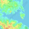
Magothy River
United States > Maryland > Anne Arundel County > Severna Park
Almost all of the creeks and tidal coves on the Magothy are named, partly as the result of a project started in 2001 by the Magothy River Association. They are shown on a map produced as part of that project, and the major ones are shown on the USGS topographic map.
Durchschnittliche Höhe: 9 m
Cape St. Claire
United States > Maryland > Anne Arundel County > Cape Saint Claire
Durchschnittliche Höhe: 12 m
Riviera Beach
United States > Maryland > Anne Arundel County > Riviera Beach
Durchschnittliche Höhe: 6 m