
Topografische Karte Lake Dora
Interaktive Karte
Klicken Sie auf die Karte, um die Höhe anzuzeigen.
Über diese Karte
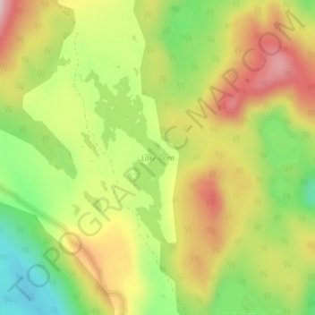
Name: Topografische Karte Lake Dora, Höhe, Relief.
Ort: Lake Dora, West Coast, Tasmania, Australia (-41.95862 145.64255 -41.94337 145.65308)
Durchschnittliche Höhe: 770 m
Minimale Höhe: 631 m
Maximale Höhe: 909 m
Andere topografische Karten
Klicken Sie auf eine Karte, um ihre Topografie, ihre Höhe und ihr Relief anzuzeigen.
Elizabeth Town
Elizabeth Town, Meander Valley, Tasmania, 7304, Australia
Durchschnittliche Höhe: 214 m
Lake St Clair
Lake St Clair, Central Highlands, Tasmania, Australia
Durchschnittliche Höhe: 909 m
Lake Louise
Lake Louise, Grindelwald, West Tamar, Tasmania, Australia
Durchschnittliche Höhe: 124 m
Garden Island
Garden Island, Huon Valley, Tasmania, Australia
Durchschnittliche Höhe: 9 m
Mole Creek
Mole Creek, Meander Valley, Tasmania, 7304, Australia
Durchschnittliche Höhe: 440 m
Launceston
Launceston, City of Launceston, Tasmania, Australia
Durchschnittliche Höhe: 194 m
Mount Field
Mount Field, Derwent Valley, Tasmania, 7140, Australia
Durchschnittliche Höhe: 720 m
Lake Margaret
Australia > Tasmania > Lake Margaret
Lake Margaret, West Coast, Tasmania, Australia
Durchschnittliche Höhe: 761 m
Bream Creek
Australia > Tasmania > Bream Creek
Bream Creek, Sorell, Tasmania, Australia
Durchschnittliche Höhe: 35 m
Cradle Mountain
Cradle Mountain, Kentish, Tasmania, Australia
Durchschnittliche Höhe: 760 m
Binalong Bay
Binalong Bay, Break O'Day, Tasmania, Australia
Durchschnittliche Höhe: 31 m
Great Lake
Great Lake, Central Highlands, Tasmania, Australia
Durchschnittliche Höhe: 1’095 m
Strathgordon
Strathgordon, Derwent Valley, Tasmania, 7139, Australia
Durchschnittliche Höhe: 388 m
North Scottsdale
North Scottsdale, Dorset, Tasmania, 7260, Australia
Durchschnittliche Höhe: 103 m
South Bruny
South Bruny, Kingborough, Tasmania, Australia
Durchschnittliche Höhe: 47 m
Prospect Vale
Australia > Tasmania > Launceston
Prospect Vale, Launceston, Meander Valley, Tasmania, 7250, Australia
Durchschnittliche Höhe: 174 m
Mount Tyndall
Mount Tyndall, West Coast, Tasmania, Australia
Durchschnittliche Höhe: 910 m
Beauty Point
Beauty Point, West Tamar, Tasmania, Australia
Durchschnittliche Höhe: 20 m
Dodges Ferry
Dodges Ferry, Sorell, Tasmania, Australia
Durchschnittliche Höhe: 20 m
West Gawler River
Australia > Tasmania > Sprent > Gawler
West Gawler River, Gawler, Sprent, Central Coast, Tasmania, Australia
Durchschnittliche Höhe: 201 m
Wellington Park
Wellington Park, Derwent Valley, Tasmania, 7054, Australia
Durchschnittliche Höhe: 419 m
Mount Ossa
Mount Ossa, Meander Valley, Tasmania, Australia
Durchschnittliche Höhe: 1’218 m
Walls Of Jerusalem
Walls Of Jerusalem, Tasmania, Australia
Durchschnittliche Höhe: 1’284 m
Roger River
Australia > Tasmania > Roger River
Roger River, Circular Head, Tasmania, Australia
Durchschnittliche Höhe: 131 m
Goose Island
Goose Island, Flinders Council, Tasmania, Australia
Durchschnittliche Höhe: 1 m