
Topografische Karte River Glen
Interaktive Karte
Klicken Sie auf die Karte, um die Höhe anzuzeigen.
Über diese Karte
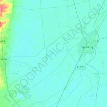
Name: Topografische Karte River Glen, Höhe, Relief.
Durchschnittliche Höhe: 5 m
Minimale Höhe: -1 m
Maximale Höhe: 53 m
Andere topografische Karten
Klicken Sie auf eine Karte, um ihre Topografie, ihre Höhe und ihr Relief anzuzeigen.
Donington CP
United Kingdom > England > Lincolnshire > South Holland
Donington CP, South Holland, Lincolnshire, England, United Kingdom
Durchschnittliche Höhe: 3 m
Spalding
United Kingdom > England > Lincolnshire > South Holland > Spalding
Spalding, South Holland, Lincolnshire, East Midlands, England, United Kingdom
Durchschnittliche Höhe: 4 m
Moulton Chapel
United Kingdom > England > Lincolnshire > South Holland > Moulton Chapel
Moulton Chapel, South Holland, Lincolnshire, East Midlands, England, PE12 0XQ, United Kingdom
Durchschnittliche Höhe: 3 m