
Spenden
Rüste dich für dein nächstes Abenteuer:
Als Amazon-Partner verdient diese Seite an qualifizierten Käufen, ohne dass Ihnen zusätzliche Kosten entstehen.
Topografische Karte Village of Cold Spring
Klicken Sie auf die Karte, um die Höhe anzuzeigen.
Spenden
Rüste dich für dein nächstes Abenteuer:
Als Amazon-Partner verdient diese Seite an qualifizierten Käufen, ohne dass Ihnen zusätzliche Kosten entstehen.
Über diese Karte
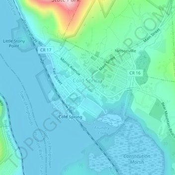
Name: Topografische Karte Village of Cold Spring, Höhe, Relief.
Durchschnittliche Höhe: 43 m
Minimale Höhe: -1 m
Maximale Höhe: 311 m
Spenden
Rüste dich für dein nächstes Abenteuer:
Als Amazon-Partner verdient diese Seite an qualifizierten Käufen, ohne dass Ihnen zusätzliche Kosten entstehen.
Andere topografische Karten
Klicken Sie auf eine Karte, um ihre Topografie, ihre Höhe und ihr Relief anzuzeigen.
Oscawana Corners
United States > New York > Putnam County > Town of Putnam Valley
Durchschnittliche Höhe: 158 m
Spenden
Rüste dich für dein nächstes Abenteuer:
Als Amazon-Partner verdient diese Seite an qualifizierten Käufen, ohne dass Ihnen zusätzliche Kosten entstehen.
Lake Peekskill
United States > New York > Putnam County > Town of Putnam Valley
Durchschnittliche Höhe: 103 m
Spenden
Rüste dich für dein nächstes Abenteuer:
Als Amazon-Partner verdient diese Seite an qualifizierten Käufen, ohne dass Ihnen zusätzliche Kosten entstehen.
Barnum Corners
United States > New York > Putnam County > Town of Patterson > Putnam Lake
Durchschnittliche Höhe: 174 m
Lake Tonetta
United States > New York > Putnam County > Brewster > Brewster Hill
Durchschnittliche Höhe: 155 m
Spenden
Rüste dich für dein nächstes Abenteuer:
Als Amazon-Partner verdient diese Seite an qualifizierten Käufen, ohne dass Ihnen zusätzliche Kosten entstehen.
Crofts Corners
United States > New York > Putnam County > Town of Putnam Valley
Durchschnittliche Höhe: 141 m
Spenden
Rüste dich für dein nächstes Abenteuer:
Als Amazon-Partner verdient diese Seite an qualifizierten Käufen, ohne dass Ihnen zusätzliche Kosten entstehen.
Kent Cliffs Unit
United States > New York > Putnam County > Town of Putnam Valley > Richardsville
Durchschnittliche Höhe: 270 m
Spenden
Rüste dich für dein nächstes Abenteuer:
Als Amazon-Partner verdient diese Seite an qualifizierten Käufen, ohne dass Ihnen zusätzliche Kosten entstehen.
Tompkins Corners
United States > New York > Putnam County > Town of Putnam Valley
Durchschnittliche Höhe: 208 m
Stillwater Pond
United States > New York > Putnam County > Town of Putnam Valley
Durchschnittliche Höhe: 288 m
Spenden
Rüste dich für dein nächstes Abenteuer:
Als Amazon-Partner verdient diese Seite an qualifizierten Käufen, ohne dass Ihnen zusätzliche Kosten entstehen.