
Topografische Karte Isla Vista
Interaktive Karte
Klicken Sie auf die Karte, um die Höhe anzuzeigen.
Über diese Karte
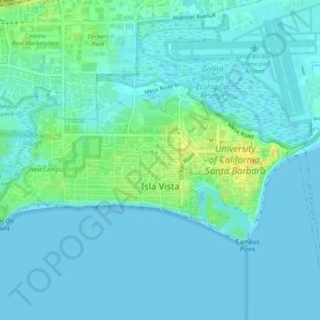
Name: Topografische Karte Isla Vista, Höhe, Relief.
Durchschnittliche Höhe: 6 m
Minimale Höhe: -2 m
Maximale Höhe: 27 m
Isla Vista is an unincorporated community and census-designated place (CDP) in Santa Barbara County, California in the United States. As of 2020 census, the community had a population of 15,500. The majority of residents are college students at the University of California, Santa Barbara or at Santa Barbara City College. The beachside community of Isla Vista lies on a flat plateau about 30 feet (9 m) in elevation, separated from the beach by a bluff.