
Spenden
Rüste dich für dein nächstes Abenteuer:
Als Amazon-Partner verdient diese Seite an qualifizierten Käufen, ohne dass Ihnen zusätzliche Kosten entstehen.
Topografische Karte Ingleside
Klicken Sie auf die Karte, um die Höhe anzuzeigen.
Spenden
Rüste dich für dein nächstes Abenteuer:
Als Amazon-Partner verdient diese Seite an qualifizierten Käufen, ohne dass Ihnen zusätzliche Kosten entstehen.
Über diese Karte
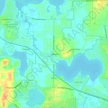
Name: Topografische Karte Ingleside, Höhe, Relief.
Ort: Ingleside, Lake County, Illinois, 60041, United States (42.36116 -88.15975 42.40116 -88.11975)
Durchschnittliche Höhe: 232 m
Minimale Höhe: 223 m
Maximale Höhe: 257 m
Spenden
Rüste dich für dein nächstes Abenteuer:
Als Amazon-Partner verdient diese Seite an qualifizierten Käufen, ohne dass Ihnen zusätzliche Kosten entstehen.
Andere topografische Karten
Klicken Sie auf eine Karte, um ihre Topografie, ihre Höhe und ihr Relief anzuzeigen.
Highland Park
United States > Illinois > Lake County
In 1867, ten men purchased Highland Park for $39,198.70. They were the original stockholders of the Highland Park Building Company. Following construction of the Chicago and Milwaukee Railroad, a depot was established at Highland Park and a plat, extending south to Central Avenue, was laid out in 1856. At that…
Durchschnittliche Höhe: 194 m
Spenden
Rüste dich für dein nächstes Abenteuer:
Als Amazon-Partner verdient diese Seite an qualifizierten Käufen, ohne dass Ihnen zusätzliche Kosten entstehen.
Spenden
Rüste dich für dein nächstes Abenteuer:
Als Amazon-Partner verdient diese Seite an qualifizierten Käufen, ohne dass Ihnen zusätzliche Kosten entstehen.
Mundelein
United States > Illinois > Lake County
Mundelein is located 33 miles (53 km) northwest of the Chicago Loop. The area of the village is 10.12 square miles (26.2 km2), 0.45 square miles (1.2 km2) of which is water. The elevation of the village is 742 feet (226 m). Mundelein borders Hawthorn Woods and Vernon Hills to the south and east, and is…
Durchschnittliche Höhe: 231 m
Spenden
Rüste dich für dein nächstes Abenteuer:
Als Amazon-Partner verdient diese Seite an qualifizierten Käufen, ohne dass Ihnen zusätzliche Kosten entstehen.
Spenden
Rüste dich für dein nächstes Abenteuer:
Als Amazon-Partner verdient diese Seite an qualifizierten Käufen, ohne dass Ihnen zusätzliche Kosten entstehen.
Spenden
Rüste dich für dein nächstes Abenteuer:
Als Amazon-Partner verdient diese Seite an qualifizierten Käufen, ohne dass Ihnen zusätzliche Kosten entstehen.
Highland Park
United States > Illinois > Lake County
In 1867, ten men purchased Highland Park for $39,198.70. They were the original stockholders of the Highland Park Building Company. Following construction of the Chicago and Milwaukee Railroad, a depot was established at Highland Park and a plat, extending south to Central Avenue, was laid out in 1856. At that…
Durchschnittliche Höhe: 193 m
Waukegan
United States > Illinois > Lake County
Waukegan is located at 42°22′13″N 87°52′16″W / 42.37028°N 87.87111°W / 42.37028; -87.87111 (42.3703140, −87.8711404). Waukegan is on the shore of Lake Michigan, about 11 miles (18 km) south of the border with Wisconsin and 37 miles (60 km) north of downtown Chicago at an elevation around…
Durchschnittliche Höhe: 197 m
Spenden
Rüste dich für dein nächstes Abenteuer:
Als Amazon-Partner verdient diese Seite an qualifizierten Käufen, ohne dass Ihnen zusätzliche Kosten entstehen.
Highland Park
United States > Illinois > Lake County
In 1867, ten men purchased Highland Park for $39,198.70. They were the original stockholders of the Highland Park Building Company. Following construction of the Chicago and Milwaukee Railroad, a depot was established at Highland Park and a plat, extending south to Central Avenue, was laid out in 1856. At that…
Durchschnittliche Höhe: 193 m
Chain O'Lakes State Park
United States > Illinois > Lake County > Fox Lake
Durchschnittliche Höhe: 238 m
Mundelein
United States > Illinois > Lake County
Mundelein is located 33 miles (53 km) northwest of the Chicago Loop. The area of the village is 10.12 square miles (26.2 km2), 0.45 square miles (1.2 km2) of which is water. The elevation of the village is 742 feet (226 m). Mundelein borders Hawthorn Woods and Vernon Hills to the south and east, and is…
Durchschnittliche Höhe: 231 m
Spenden
Rüste dich für dein nächstes Abenteuer:
Als Amazon-Partner verdient diese Seite an qualifizierten Käufen, ohne dass Ihnen zusätzliche Kosten entstehen.
Highwood
United States > Illinois > Lake County
Highwood is located in southeastern Lake County at 42°12′19″N 87°48′44″W / 42.205357°N 87.812345°W / 42.205357; -87.812345, on a ridge 100 feet (30 m) above the elevation of Lake Michigan.
Durchschnittliche Höhe: 198 m
Spenden
Rüste dich für dein nächstes Abenteuer:
Als Amazon-Partner verdient diese Seite an qualifizierten Käufen, ohne dass Ihnen zusätzliche Kosten entstehen.
Highland Park
United States > Illinois > Lake County
In 1867, ten men purchased Highland Park for $39,198.70. They were the original stockholders of the Highland Park Building Company. Following construction of the Chicago and Milwaukee Railroad, a depot was established at Highland Park and a plat, extending south to Central Avenue, was laid out in 1856. At that…
Durchschnittliche Höhe: 194 m
Spenden
Rüste dich für dein nächstes Abenteuer:
Als Amazon-Partner verdient diese Seite an qualifizierten Käufen, ohne dass Ihnen zusätzliche Kosten entstehen.
Spenden
Rüste dich für dein nächstes Abenteuer:
Als Amazon-Partner verdient diese Seite an qualifizierten Käufen, ohne dass Ihnen zusätzliche Kosten entstehen.
Spenden
Rüste dich für dein nächstes Abenteuer:
Als Amazon-Partner verdient diese Seite an qualifizierten Käufen, ohne dass Ihnen zusätzliche Kosten entstehen.
Forrestal Village
United States > Illinois > Lake County > North Chicago
Durchschnittliche Höhe: 211 m
Mundelein
United States > Illinois > Lake County
Mundelein is located 33 miles (53 km) northwest of the Chicago Loop. The area of the village is 10.12 square miles (26.2 km2), 0.45 square miles (1.2 km2) of which is water. The elevation of the village is 742 feet (226 m). Mundelein borders Hawthorn Woods and Vernon Hills to the south and east, and is…
Durchschnittliche Höhe: 231 m
Spenden
Rüste dich für dein nächstes Abenteuer:
Als Amazon-Partner verdient diese Seite an qualifizierten Käufen, ohne dass Ihnen zusätzliche Kosten entstehen.
Spenden
Rüste dich für dein nächstes Abenteuer:
Als Amazon-Partner verdient diese Seite an qualifizierten Käufen, ohne dass Ihnen zusätzliche Kosten entstehen.
Highland Park
United States > Illinois > Lake County
In 1867, ten men purchased Highland Park for $39,198.70. They were the original stockholders of the Highland Park Building Company. Following construction of the Chicago and Milwaukee Railroad, a depot was established at Highland Park and a plat, extending south to Central Avenue, was laid out in 1856. At that…
Durchschnittliche Höhe: 194 m
Spenden
Rüste dich für dein nächstes Abenteuer:
Als Amazon-Partner verdient diese Seite an qualifizierten Käufen, ohne dass Ihnen zusätzliche Kosten entstehen.
Lake Zurich
United States > Illinois > Lake County
Lake Zurich is located at 42°11′32″N 88°5′17″W / 42.19222°N 88.08806°W / 42.19222; -88.08806 (42.192324, -88.088098), with an elevation of 850 feet (260 m) above sea level.
Durchschnittliche Höhe: 259 m
Spenden
Rüste dich für dein nächstes Abenteuer:
Als Amazon-Partner verdient diese Seite an qualifizierten Käufen, ohne dass Ihnen zusätzliche Kosten entstehen.
Round Lake Beach
United States > Illinois > Lake County > Round Lake Beach
Durchschnittliche Höhe: 240 m
Spenden
Rüste dich für dein nächstes Abenteuer:
Als Amazon-Partner verdient diese Seite an qualifizierten Käufen, ohne dass Ihnen zusätzliche Kosten entstehen.