
Spenden
Rüste dich für dein nächstes Abenteuer:
Als Amazon-Partner verdient diese Seite an qualifizierten Käufen, ohne dass Ihnen zusätzliche Kosten entstehen.
Topografische Karte Stanwood
Klicken Sie auf die Karte, um die Höhe anzuzeigen.
Spenden
Rüste dich für dein nächstes Abenteuer:
Als Amazon-Partner verdient diese Seite an qualifizierten Käufen, ohne dass Ihnen zusätzliche Kosten entstehen.
Stanwood
The city is located at the mouth of the Stillaguamish River, where it flows into Port Susan, an arm of the Puget Sound, and Skagit Bay, the mouth of the Skagit River. To the west is Davis Slough, which separates Stanwood from Camano Island and forms the border between Snohomish and Island counties. Elevations in Stanwood range from 2 feet (0.61 m) above sea level near the Stillaguamish River to 190 feet (58 m) in the northeastern hills. The city is home to five creeks and drainage basins that flow into the Stillaguamish River and Puget Sound: Church Creek, Douglas Creek, Irvine Slough, the Skagit River, and the Stillaguamish River. The Stanwood area was formed during the Pleistocene glaciation and was further shaped through the rise and fall of the sea level as well as sedimentary deposits from the Skagit and Stillaguamish rivers.
Spenden
Rüste dich für dein nächstes Abenteuer:
Als Amazon-Partner verdient diese Seite an qualifizierten Käufen, ohne dass Ihnen zusätzliche Kosten entstehen.
Über diese Karte
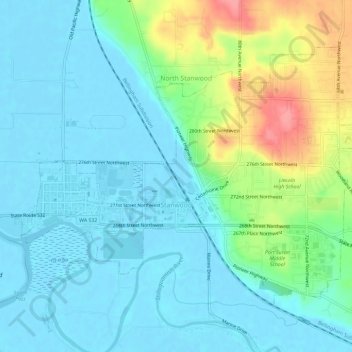
Name: Topografische Karte Stanwood, Höhe, Relief.
Durchschnittliche Höhe: 20 m
Minimale Höhe: -2 m
Maximale Höhe: 83 m
Spenden
Rüste dich für dein nächstes Abenteuer:
Als Amazon-Partner verdient diese Seite an qualifizierten Käufen, ohne dass Ihnen zusätzliche Kosten entstehen.
Andere topografische Karten
Klicken Sie auf eine Karte, um ihre Topografie, ihre Höhe und ihr Relief anzuzeigen.
Northwest Snohomish
United States > Washington > Snohomish County > Snohomish
Durchschnittliche Höhe: 52 m
Spenden
Rüste dich für dein nächstes Abenteuer:
Als Amazon-Partner verdient diese Seite an qualifizierten Käufen, ohne dass Ihnen zusätzliche Kosten entstehen.
Glacier Peak
United States > Washington > Snohomish County
Despite its elevation of 10,541 feet (3,213 m), Glacier Peak is a small stratovolcano. Its relatively high summit is a consequence of its location atop a high ridge, but its volcanic portion extends only 1,600–3,200 feet (500–1,000 m) above the underlying ridge. Another Cascade Arc volcano with similar…
Durchschnittliche Höhe: 2’656 m
Spenden
Rüste dich für dein nächstes Abenteuer:
Als Amazon-Partner verdient diese Seite an qualifizierten Käufen, ohne dass Ihnen zusätzliche Kosten entstehen.
Bridal Veil Falls-Lower East Cascade
United States > Washington > Snohomish County
Durchschnittliche Höhe: 621 m
Spenden
Rüste dich für dein nächstes Abenteuer:
Als Amazon-Partner verdient diese Seite an qualifizierten Käufen, ohne dass Ihnen zusätzliche Kosten entstehen.
Whitehorse Mountain
United States > Washington > Snohomish County
Whitehorse Mountain is a peak near the western edge of the North Cascades in Washington state. It is located just southwest of the Sauk River Valley town of Darrington, near the northern boundary of Boulder River Wilderness in Mount Baker-Snoqualmie National Forest. While not of particularly high absolute…
Durchschnittliche Höhe: 1’430 m
Lynnwood
United States > Washington > Snohomish County > Lynnwood > Lynnwood
Durchschnittliche Höhe: 112 m
Spenden
Rüste dich für dein nächstes Abenteuer:
Als Amazon-Partner verdient diese Seite an qualifizierten Käufen, ohne dass Ihnen zusätzliche Kosten entstehen.
Mill Creek
United States > Washington > Snohomish County > Mill Creek > Mill Creek
Durchschnittliche Höhe: 129 m
Spenden
Rüste dich für dein nächstes Abenteuer:
Als Amazon-Partner verdient diese Seite an qualifizierten Käufen, ohne dass Ihnen zusätzliche Kosten entstehen.