
Topografische Karte Kea
Interaktive Karte
Klicken Sie auf die Karte, um die Höhe anzuzeigen.
Über diese Karte
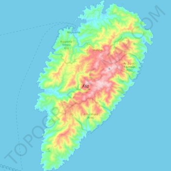
Name: Topografische Karte Kea, Höhe, Relief.
Durchschnittliche Höhe: 81 m
Minimale Höhe: 0 m
Maximale Höhe: 565 m
Its capital, Ioulis, is inland at a high altitude (like most ancient Cycladic settlements, for fear of pirates) and is considered quite picturesque. Other major villages of Kea are the port of Korissia and the fishing village of Vourkari. After suffering depopulation for many decades, Kea has been recently rediscovered by Athenians as a convenient destination for weekend and yachting trips. The population in 2019 was 2,568.
Andere topografische Karten
Klicken Sie auf eine Karte, um ihre Topografie, ihre Höhe und ihr Relief anzuzeigen.
Βουρκάρι
Greece > Aegean > Kea-Kythnos Regional Unit > Korissia
Βουρκάρι, Korissia, Kea Municipality, Kea-Kythnos Regional Unit, South Aegean, Aegean, 840 02, Greece
Durchschnittliche Höhe: 63 m